File:Connaught (Knock) Airport - geograph.org.uk - 1011331.jpg
From Wikishire
No higher resolution available.
Connaught_(Knock)_Airport_-_geograph.org.uk_-_1011331.jpg (640 × 418 pixels, file size: 47 KB, MIME type: image/jpeg)
_Airport_-_geograph.org.uk_-_1011331.jpg)
Summary
| Description |
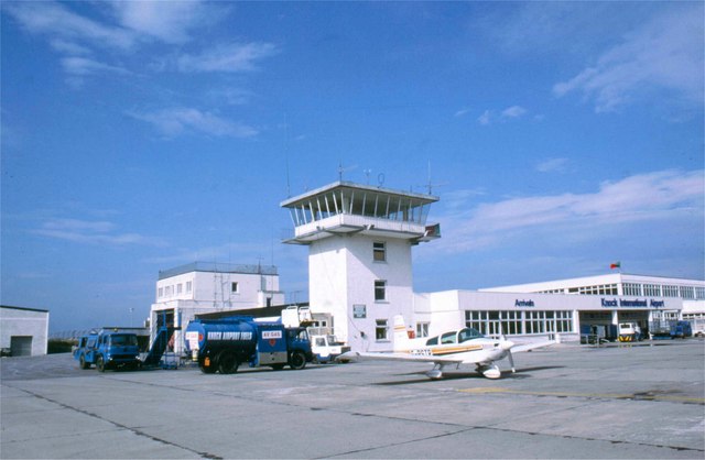
English: Connaught (Knock) Airport A light aircraft parked at the Control Tower of the airport which was built mainly to serve flights bringing visitors to the nearby shrine in Knock. This is a major pilgrimage site in County Mayo where Catholics believe that in 1879 there was an apparition of the Virgin Mary, St Joseph, St John the Evangelist and Jesus Christ (as the Lamb of God).
This large airport was controversially built after Knock's parish priest James Horan persuaded Irish Taoiseach Charles Haughey to release millions of pounds of state aid for its construction. At the time this was condemned by critics in the media. However, the airport now draws not just pilgrims but many other passengers and functions as a useful air-gateway for the entire Connaught region |
| Date | |
| Source | From geograph.org.uk |
| Author | James Allan |
| Attribution (required by the license) | James Allan / Connaught (Knock) Airport / |
| Camera location | | View this and other nearby images on: OpenStreetMap |
|---|
_Airport_-_geograph.org.uk_-_1011331.jpg¶ms=053.912850_N_-008.814800_E_globe:Earth_type:camera_source:geograph-irishgrid(M46509623)_heading:270.00&language=en)
| Object location | | View this and other nearby images on: OpenStreetMap |
|---|
_Airport_-_geograph.org.uk_-_1011331.jpg¶ms=053.913000_N_-008.817000_E_globe:Earth_class:object_type:object_source:geograph-irishgrid(M463962)_heading:270.00&language=en)
Licensing

|
This image was taken from the Geograph project collection. See this photograph's page on the Geograph website for the photographer's contact details. The copyright on this image is owned by James Allan and is licensed for reuse under the Creative Commons Attribution-ShareAlike 2.0 license.
|
This file is licensed under the Creative Commons Attribution-Share Alike 2.0 Generic license.
Attribution: James Allan
- You are free:
- to share – to copy, distribute and transmit the work
- to remix – to adapt the work
- Under the following conditions:
- attribution – You must give appropriate credit, provide a link to the license, and indicate if changes were made. You may do so in any reasonable manner, but not in any way that suggests the licensor endorses you or your use.
- share alike – If you remix, transform, or build upon the material, you must distribute your contributions under the same or compatible license as the original.
File history
Click on a date/time to view the file as it appeared at that time.
| Date/Time | Thumbnail | Dimensions | User | Comment | |
|---|---|---|---|---|---|
| current | 10:25, 23 February 2011 | | 640 × 418 (47 KB) | GeographBot | == {{int:filedesc}} == {{Information |description={{en|1=Connaught (Knock) Airport A light aircraft parked at the Control Tower of the airport which was built mainly to serve flights bringing visitors to the nearby shrine in Knock. This is a major pilgrim |
File usage
The following file is a duplicate of this file (more details):
_Airport_-_geograph.org.uk_-_1011331.jpg)
- File:Connaught (Knock) Airport - geograph.org.uk - 1011331.jpg from a shared repository
The following page links to this file:
_Airport_-_geograph.org.uk_-_1011331.jpg)
_Airport_-_geograph.org.uk_-_1011331.jpg)
_Airport_-_geograph.org.uk_-_1011331.jpg&action=edit&redlink=1)
_Airport_-_geograph.org.uk_-_1011331.jpg)
_Airport_-_geograph.org.uk_-_1011331.jpg&printable=yes)
_Airport_-_geograph.org.uk_-_1011331.jpg&action=info)