File:Connacht locator map.svg
From Wikishire

Size of this preview: 459 × 599 pixels. Other resolution: 184 × 240 pixels.
Original file (SVG file, nominally 1,264 × 1,649 pixels, file size: 593 KB)
Summary
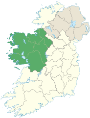
| Description | Locator map of Connacht. |
| Date | (UTC) |
| Source | |
| Author |
|
Licensing
I, the copyright holder of this work, hereby publish it under the following license:
This file is licensed under the Creative Commons Attribution-Share Alike 3.0 Unported license.
- You are free:
- to share – to copy, distribute and transmit the work
- to remix – to adapt the work
- Under the following conditions:
- attribution – You must give appropriate credit, provide a link to the license, and indicate if changes were made. You may do so in any reasonable manner, but not in any way that suggests the licensor endorses you or your use.
- share alike – If you remix, transform, or build upon the material, you must distribute your contributions under the same or compatible license as the original.
File history
Click on a date/time to view the file as it appeared at that time.
| Date/Time | Thumbnail | Dimensions | User | Comment | |
|---|---|---|---|---|---|
| current | 14:18, 8 June 2013 | | 1,264 × 1,649 (593 KB) | Setanta Saki | Including Aran Islands are part of province of Connacht |
File usage
The following file is a duplicate of this file (more details):
- File:Connacht locator map.svg from a shared repository
The following page links to this file: