File:Cliffe Cut.jpg
From Wikishire
No higher resolution available.
Cliffe_Cut.jpg (640 × 479 pixels, file size: 122 KB, MIME type: image/jpeg)
Summary
| Description |
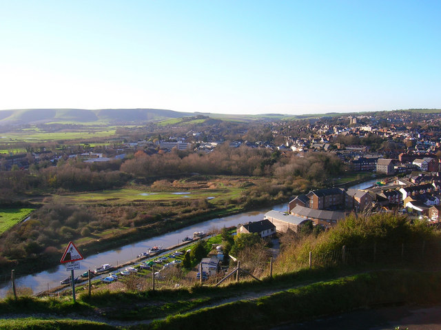
English: Cliffe Cut, River Ouse Taken from the cliff on Chapel Hill near the golf club and looking down onto the town. The stretch of river in the foreground is Cliffe Cut undertaken when the Ouse was canalised in the late 1790s. The original course of the river meandered to the east by the boathouse next to Hilman Close, the circular set of flats. Beyond the river can be seen the Heart Of Reeds which can be found 291632 along with an opposite view. It was also at this point that Britain's worst ever avalanche occurred on Christmas Eve 1836 when a 15 foot snowdrift perched on this cliff top collapsed onto houses below killing 8 people. The current Snowdrop Inn below is named after this event.
Other views which can be taken in include the castle to the right and the downs at Kingston ridge on the left hand side. |
| Date | |
| Source | From geograph.org.uk |
| Author | Simon Carey |
| Camera location | | View this and other nearby images on: OpenStreetMap |
|---|
Licensing

|
This image was taken from the Geograph project collection. See this photograph's page on the Geograph website for the photographer's contact details. The copyright on this image is owned by Simon Carey and is licensed for reuse under the Creative Commons Attribution-ShareAlike 2.0 license.
|
This file is licensed under the Creative Commons Attribution-Share Alike 2.0 Generic license.
Attribution: Simon Carey
- You are free:
- to share – to copy, distribute and transmit the work
- to remix – to adapt the work
- Under the following conditions:
- attribution – You must give appropriate credit, provide a link to the license, and indicate if changes were made. You may do so in any reasonable manner, but not in any way that suggests the licensor endorses you or your use.
- share alike – If you remix, transform, or build upon the material, you must distribute your contributions under the same or compatible license as the original.
File history
Click on a date/time to view the file as it appeared at that time.
| Date/Time | Thumbnail | Dimensions | User | Comment | |
|---|---|---|---|---|---|
| current | 15:24, 9 October 2007 | | 640 × 479 (122 KB) | Derek Andrews | {{Information |Description=This tidal stretch of the River Ouse just south of Lewes is Cliffe Cut. It was made when the Ouse was canalised in the late 1790s. The original course of the river meandered in the foreground. |Source=http://www.geograph.org.uk/ |
File usage
The following file is a duplicate of this file (more details):
- File:Cliffe Cut.jpg from a shared repository
The following page links to this file: