File:Charcot Island, Antarctica.png
From Wikishire

Size of this preview: 697 × 600 pixels. Other resolution: 279 × 240 pixels.
Original file (925 × 796 pixels, file size: 441 KB, MIME type: image/png)
Summary
| Description |
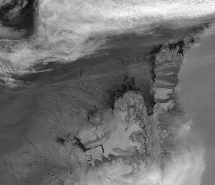
English: This image is made from thermal infra-red data collected by the Moderate Resolution Imaging Spectroradiometer (MODIS) on NASA’s Terra satellite. (A photo-like image isn’t possible at this latitude in the winter because of polar darkness). This greyscale image shows relative differences in surface temperature. Dark grey indicates relatively warm temperatures and white indicates relatively cold temperatures. Remnant ice shelf east of Latady Island appears white, as does some of the sea ice between Charcot and Latady Islands. Charcot Island’s nearly black perimeter indicates an area of relatively open ocean that could be navigated by ship. In addition, an area of relatively warm ocean water appears off the western end of Latady Island. |
| Date | |
| Source | NASA Earth Observatory |
| Author | Jesse Allen |
Data obtained from the Goddard Level 1 and Atmospheric Archive and Distribution System (LAADS). Image interpretation by Ted Scambos, National Snow and Ice Data Centre. Instrument: Terra - MODIS.
Licensing
| This file is in the public domain in the United States because it was solely created by NASA. NASA copyright policy states that "NASA material is not protected by copyright unless noted". (See Template:PD-USGov, NASA copyright policy page or JPL Image Use Policy.) | ||
 |
Warnings:
|
File history
Click on a date/time to view the file as it appeared at that time.
| Date/Time | Thumbnail | Dimensions | User | Comment | |
|---|---|---|---|---|---|
| current | 09:02, 14 August 2009 | | 925 × 796 (441 KB) | Originalwana | {{Information |Description={{en|1=This image is made from thermal infra-red data collected by the Moderate Resolution Imaging Spectroradiometer (MODIS) on NASA’s Terra satellite. (A photo-like image isn’t possible at this latitude in the winter becaus |
File usage
The following file is a duplicate of this file (more details):
- File:Charcot Island, Antarctica.png from a shared repository
The following page links to this file: