File:Cautley Spout - geograph.org.uk - 243601.jpg
From Wikishire

Size of this preview: 450 × 600 pixels. Other resolution: 180 × 240 pixels.
Original file (480 × 640 pixels, file size: 87 KB, MIME type: image/jpeg)
Summary
| Description |
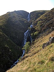
English: Cautley Spout. The upper section of the waterfall. The line of the stream turns by 90 degrees below this point and continues to cascade. The following lower section can be seen from quite a distance away: 243597. |
| Date | |
| Source | From geograph.org.uk |
| Author | Rudi Winter |
| Attribution (required by the license) | Rudi Winter / Cautley Spout / |
| Camera location | | View this and other nearby images on: OpenStreetMap |
|---|
_heading:225.00&language=en)
| Object location | | View this and other nearby images on: OpenStreetMap |
|---|
_heading:225.00&language=en)
Licensing

|
This image was taken from the Geograph project collection. See this photograph's page on the Geograph website for the photographer's contact details. The copyright on this image is owned by Rudi Winter and is licensed for reuse under the Creative Commons Attribution-ShareAlike 2.0 license.
|
This file is licensed under the Creative Commons Attribution-Share Alike 2.0 Generic license.
Attribution: Rudi Winter
- You are free:
- to share – to copy, distribute and transmit the work
- to remix – to adapt the work
- Under the following conditions:
- attribution – You must give appropriate credit, provide a link to the license, and indicate if changes were made. You may do so in any reasonable manner, but not in any way that suggests the licensor endorses you or your use.
- share alike – If you remix, transform, or build upon the material, you must distribute your contributions under the same or compatible license as the original.
File history
Click on a date/time to view the file as it appeared at that time.
| Date/Time | Thumbnail | Dimensions | User | Comment | |
|---|---|---|---|---|---|
| current | 23:07, 31 January 2010 | | 480 × 640 (87 KB) | GeographBot | == {{int:filedesc}} == {{Information |description={{en|1=Cautley Spout. The upper section of the waterfall. The line of the stream turns by 90 degrees below this point and continues to cascade. The following lower section can be seen from quite a distan |
File usage
The following file is a duplicate of this file (more details):
- File:Cautley Spout - geograph.org.uk - 243601.jpg from a shared repository
The following page links to this file: