File:Causey Park House - geograph.org.uk - 470743.jpg
From Wikishire
No higher resolution available.
Causey_Park_House_-_geograph.org.uk_-_470743.jpg (640 × 480 pixels, file size: 89 KB, MIME type: image/jpeg)
Summary
| Description |
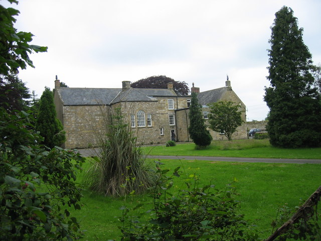
English: Causey Park House Keys to the Past Web Site: This house was first built in the late 16th century. It is a large rectangular building, with stair tower behind it. At the west end is a cross wing. Large stones at the base of the building were probably of 14th or 15th century date. Other parts of the building appear to belong to the 16th century.
Grid line 95 slices through the house. |
| Date | |
| Source | From geograph.org.uk |
| Author | Les Hull |
| Attribution (required by the license) | Les Hull / Causey Park House / |
| Camera location | | View this and other nearby images on: OpenStreetMap |
|---|
_heading:247.00&language=en)
| Object location | | View this and other nearby images on: OpenStreetMap |
|---|
_heading:247.00&language=en)
Licensing

|
This image was taken from the Geograph project collection. See this photograph's page on the Geograph website for the photographer's contact details. The copyright on this image is owned by Les Hull and is licensed for reuse under the Creative Commons Attribution-ShareAlike 2.0 license.
|
This file is licensed under the Creative Commons Attribution-Share Alike 2.0 Generic license.
Attribution: Les Hull
- You are free:
- to share – to copy, distribute and transmit the work
- to remix – to adapt the work
- Under the following conditions:
- attribution – You must give appropriate credit, provide a link to the license, and indicate if changes were made. You may do so in any reasonable manner, but not in any way that suggests the licensor endorses you or your use.
- share alike – If you remix, transform, or build upon the material, you must distribute your contributions under the same or compatible license as the original.
File history
Click on a date/time to view the file as it appeared at that time.
| Date/Time | Thumbnail | Dimensions | User | Comment | |
|---|---|---|---|---|---|
| current | 21:48, 4 February 2011 | | 640 × 480 (89 KB) | GeographBot | == {{int:filedesc}} == {{Information |description={{en|1=Causey Park House Keys to the Past Web Site: This house was first built in the late 16th century. It is a large rectangular building, with stair tower behind it. At the west end is a cross wing. Lar |
File usage
The following file is a duplicate of this file (more details):
- File:Causey Park House - geograph.org.uk - 470743.jpg from a shared repository
The following page links to this file: