File:Castles of Munster, Lismore, Waterford-geograph-3038250.jpg
From Wikishire

Size of this preview: 800 × 534 pixels. Other resolution: 320 × 213 pixels.
Original file (1,024 × 683 pixels, file size: 883 KB, MIME type: image/jpeg)
Summary
| Description |
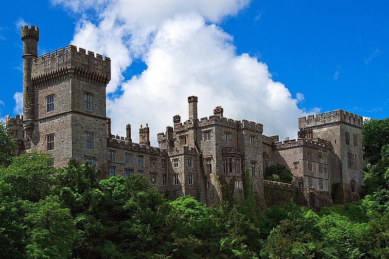
English: Castles of Munster: Lismore, Waterford. A castle has stood on this site since Prince John built a castle here above the River Blackwater in 1185. This was soon destroyed but later rebuilt, and provided a residence throughout the medieval period for the bishops of Lismore. It was damaged during the Desmond Rebellion of 1579 and was entirely rebuilt in 1621 by Sir Richard Boyle after its previous owner Sir Walter Raleigh was executed. At the end of the wars that devastated Ireland in the mid-C17 it was again in a ruinous state, and was remodelled by the 2nd Earl of Cork in the 1660s. After its neglect during the C18, a complete rebuilding was undertaken by the 6th Duke of Devonshire, whose descendants remain the current owners. The building works of 1814 totally transformed the old castle. The upper parts, the present battlements and turrets, and the majority of the features, date from this early C19 rebuilding, and it is just the lower parts of the old C17 walls that remain. There are also original gunloops in the NE tower, and in a circular tower on the west side, whilst the SE tower has older work up as far as the third storey. |
| Date | |
| Source | https://www.geograph.org.uk/photo/3038250 |
| Author | https://www.geograph.org.uk/profile/10423 Mike Searle] |
| Attribution (required by the license) | Mike Searle / Castles of Munster: Lismore, Waterford (3) / |
| Camera location | | View this and other nearby images on: OpenStreetMap |
|---|
_heading:225.00&language=en)
| Object location | | View this and other nearby images on: OpenStreetMap |
|---|
_heading:225.00&language=en)
Licensing

|
This image was taken from the Geograph project collection. See this photograph's page on the Geograph website for the photographer's contact details. The copyright on this image is owned by Mike Searle and is licensed for reuse under the Creative Commons Attribution-ShareAlike 2.0 license.
|
This file is licensed under the Creative Commons Attribution-Share Alike 2.0 Generic license.
Attribution: Mike Searle
- You are free:
- to share – to copy, distribute and transmit the work
- to remix – to adapt the work
- Under the following conditions:
- attribution – You must give appropriate credit, provide a link to the license, and indicate if changes were made. You may do so in any reasonable manner, but not in any way that suggests the licensor endorses you or your use.
- share alike – If you remix, transform, or build upon the material, you must distribute your contributions under the same or compatible license as the original.
File history
Click on a date/time to view the file as it appeared at that time.
| Date/Time | Thumbnail | Dimensions | User | Comment | |
|---|---|---|---|---|---|
| current | 10:02, 21 July 2021 | | 1,024 × 683 (883 KB) | Geograph Update Bot | Higher-resolution version from Geograph |
File usage
The following file is a duplicate of this file (more details):
- File:Castles of Munster, Lismore, Waterford-geograph-3038250.jpg from a shared repository
The following 2 pages link to this file: