File:Carrick Kildavnet Castle - geograph.org.uk - 471756.jpg
From Wikishire
Size of this preview: 240 × 598 pixels.
Original file (257 × 640 pixels, file size: 63 KB, MIME type: image/jpeg)
Summary
| Description |
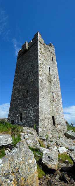
English: Carrick Kildavnet Castle Carrick Kildavnet (or Kildavnet) Castle is a late 15th century fortified Tower House set at the water's edge with remains of a boat slipway which ran from the back of the castle. It is associated with the famous sea-pirate Grace OMalley (Granuaile) and was probably built by one of her ancestors. It is about four storeys high and stands to full height. There is no stairway from the ground or first floor levels and access to the upper storeys is not possible. It is vaulted above the first floor and a hole at the corner of this vault is the only access to the higher levels. There appears to be a small mural chamber at the first floor. The tower has a machicolation at roof level in the middle of the three walls on the landward side. At one corner is the base of a short stretch of bawn wall with remains of a round flanking tower. The castle has many small defensive loops with larger windows at the higher levels, including one over the doorway. Some of the loops have slopstones which are visible from the outside. |
| Date | |
| Source | From geograph.org.uk |
| Author | Mike Shinners |
| Attribution (required by the license) | Mike Shinners / Carrick Kildavnet Castle / |
| Camera location | | View this and other nearby images on: OpenStreetMap |
|---|
_heading:315.00&language=en)
| Object location | | View this and other nearby images on: OpenStreetMap |
|---|
_heading:315.00&language=en)
Licensing

|
This image was taken from the Geograph project collection. See this photograph's page on the Geograph website for the photographer's contact details. The copyright on this image is owned by Mike Shinners and is licensed for reuse under the Creative Commons Attribution-ShareAlike 2.0 license.
|
This file is licensed under the Creative Commons Attribution-Share Alike 2.0 Generic license.
Attribution: Mike Shinners
- You are free:
- to share – to copy, distribute and transmit the work
- to remix – to adapt the work
- Under the following conditions:
- attribution – You must give appropriate credit, provide a link to the license, and indicate if changes were made. You may do so in any reasonable manner, but not in any way that suggests the licensor endorses you or your use.
- share alike – If you remix, transform, or build upon the material, you must distribute your contributions under the same or compatible license as the original.
- Remove redundant categories and try to put this image in the most specific category/categories
- Remove this template
- The location categories are based on information from this geonames tool and this OpenStreetMap tool combined with a database. You can also have a look at this tool from mysociety.
- The topic category from Geograph was Castle (find similar images at Geograph)
File history
Click on a date/time to view the file as it appeared at that time.
| Date/Time | Thumbnail | Dimensions | User | Comment | |
|---|---|---|---|---|---|
| current | 21:46, 4 February 2011 | 257 × 640 (63 KB) | GeographBot | == {{int:filedesc}} == {{Information |description={{en|1=Carrick Kildavnet Castle Carrick Kildavnet (or Kildavnet) Castle is a late 15th century fortified Tower House set at the water's edge with remains of a boat slipway which ran from the back of the ca |
File usage
The following file is a duplicate of this file (more details):
- File:Carrick Kildavnet Castle - geograph.org.uk - 471756.jpg from a shared repository
The following page links to this file: