File:Caernarfon Castle plan labelled.png
From Wikishire
Size of this preview: 799 × 372 pixels. Other resolution: 320 × 149 pixels.
Original file (829 × 386 pixels, file size: 395 KB, MIME type: image/png)
Summary
| Description |
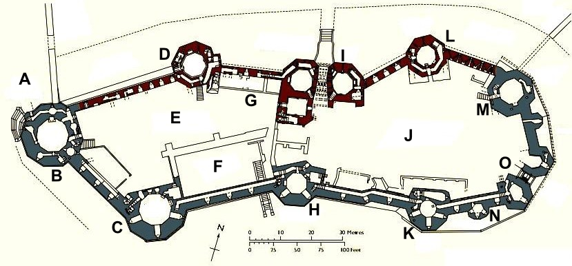
English: Plan of Caernarfon Castle; adapted, with wording replaced with labels |
| Date | Unknown date |
| Source | http://cadw.wales.gov.uk/docs/cadw/publications/WHS_additional_maps_plans_EN.pdf |
| Author | Cadw |
| Permission (Reusing this file) |
Copyright status at http://cadw.wales.gov.uk/copyright/?lang=en |
Licensing
.svg)
|
This file is licensed under the Open Government Licence version 1.0 (OGL v1.0).
|
|---|---|
|
You are free to:
See the Open Government Licence page on Meta-Wiki for more information.
|
File history
Click on a date/time to view the file as it appeared at that time.
| Date/Time | Thumbnail | Dimensions | User | Comment | |
|---|---|---|---|---|---|
| current | 06:49, 11 September 2011 | | 829 × 386 (395 KB) | Hchc2009 | {{Information |Description ={{en|1=Plan of Caernarfon Castle; adapted, with wording replaced with labels}} |Source =http://cadw.wales.gov.uk/docs/cadw/publications/WHS_additional_maps_plans_EN.pdf |Author =Cadw |Date =Unknown |
File usage
The following file is a duplicate of this file (more details):
- File:Caernarfon Castle plan labelled.png from a shared repository
The following page links to this file: