File:Cadbury Castle Somerset Map.jpg

Summary
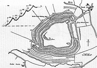
| Description | Map of earthworks at Cadbury Castle, Somerset, England. |
| Date | |
| Source | The Victoria History of the Counties of England, A History Of Somerset, Volume 2. |
| Author | Editor - W.Page; Chapter on Ancient Earthworks - C.H.Bothamley |
| Permission (Reusing this file) |
Copyright has expired in the United Kingdom, and is believed to be in the public domain. |
Licensing
|
This work is in the public domain in its country of origin and other countries and areas where the copyright term is the author's life plus 70 years or fewer.
| |
| This file has been identified as being free of known restrictions under copyright law, including all related and neighboring rights. | |
File history
Click on a date/time to view the file as it appeared at that time.
| Date/Time | Thumbnail | Dimensions | User | Comment | |
|---|---|---|---|---|---|
| current | 12:51, 10 December 2006 | | 825 × 580 (126 KB) | Mikhailfranco~commonswiki | {{Information |Description=Map of earthworks at Cadbury Castle, Somerset, England. |Source=The Victoria History of the Counties of England, A History Of Somerset, Volume 2. |Date=1911 |Author=Editor - W.Page; Chapter on Ancient Earthworks - C.H.Bothamley |
File usage
The following file is a duplicate of this file (more details):
- File:Cadbury Castle Somerset Map.jpg from a shared repository
The following page links to this file: