File:Byards Leap - geograph.org.uk - 130593.jpg
From Wikishire
No higher resolution available.
Byards_Leap_-_geograph.org.uk_-_130593.jpg (640 × 427 pixels, file size: 158 KB, MIME type: image/jpeg)
Summary
| Description |
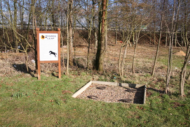
English: Byards Leap. According to local legend, hundreds of years ago, an ugly old witch called Meg and her black cat were held responsible for failing crops and dying cattle on Ancaster Heath. A local knight 'Big Jim' and his trusty steed Byard approached the witches hovel .... she attacked them and sunk her claws into Byard who made a prodigious leap, greater than any horse had ever made before. The witch fell off whereupon Big Jim dismounted and killed her. The four horseshoes mark the spot where Byard landed and has been known as 'Byard's Leap' ever since. A true story ? |
| Date | |
| Source | From geograph.org.uk |
| Author | Richard Croft |
| Attribution (required by the license) | Richard Croft / Byards Leap / |
| Camera location | | View this and other nearby images on: OpenStreetMap |
|---|
_heading:45.00&language=en)
| Object location | | View this and other nearby images on: OpenStreetMap |
|---|
_heading:45.00&language=en)
Licensing

|
This image was taken from the Geograph project collection. See this photograph's page on the Geograph website for the photographer's contact details. The copyright on this image is owned by Richard Croft and is licensed for reuse under the Creative Commons Attribution-ShareAlike 2.0 license.
|
This file is licensed under the Creative Commons Attribution-Share Alike 2.0 Generic license.
Attribution: Richard Croft
- You are free:
- to share – to copy, distribute and transmit the work
- to remix – to adapt the work
- Under the following conditions:
- attribution – You must give appropriate credit, provide a link to the license, and indicate if changes were made. You may do so in any reasonable manner, but not in any way that suggests the licensor endorses you or your use.
- share alike – If you remix, transform, or build upon the material, you must distribute your contributions under the same or compatible license as the original.
- Remove redundant categories and try to put this image in the most specific category/categories
- Remove this template
- The location categories are based on information from this geonames tool and this OpenStreetMap tool combined with a database. You can also have a look at this tool from mysociety.
- The topic category from Geograph was Curiosity (find similar images at Geograph)
File history
Click on a date/time to view the file as it appeared at that time.
| Date/Time | Thumbnail | Dimensions | User | Comment | |
|---|---|---|---|---|---|
| current | 03:28, 31 January 2010 | | 640 × 427 (158 KB) | GeographBot | == {{int:filedesc}} == {{Information |description={{en|1=Byards Leap. According to local legend, hundreds of years ago, an ugly old witch called Meg and her black cat were held responsible for failing crops and dying cattle on Ancaster Heath. A local knig |
File usage
The following file is a duplicate of this file (more details):
- File:Byards Leap - geograph.org.uk - 130593.jpg from a shared repository
The following page links to this file: