File:Burnham Overy 4.jpg
From Wikishire

Size of this preview: 800 × 533 pixels. Other resolution: 320 × 213 pixels.
Original file (2,160 × 1,440 pixels, file size: 469 KB, MIME type: image/jpeg)
Summary
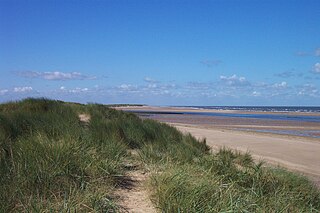
| Description | The coast near Burnham Overy Staithe, taken from the crest of the dunes at the end of the footpath from Staithe to beach. Beyond the dunes can be seen the entrance to the River Burn, which gives boat access to the Staithe. Beyond that is Scolt Head Island, a nature reserve accessible only by boat. For more information see the Wikipedia article Burnham Overy. |
| Date | Taken on 15 September 2004, 12:33 |
| Source | Photograph by myself with original filename DCP_3212.JPG. Unmodified. |
| Author | Chris Wood (User:chris_j_wood). |
| Permission (Reusing this file) |
Copyright (c) 2004 Chris Wood. Uploaded by the copyright holder under the terms of the GFDL (see below). |
| Other versions |
| Camera location | | View this and other nearby images on: OpenStreetMap |
|---|
Licensing
I, the copyright holder of this work, hereby publish it under the following licenses:
This file is licensed under the Creative Commons Attribution-Share Alike 4.0 International license.
Attribution: Chris Wood
- You are free:
- to share – to copy, distribute and transmit the work
- to remix – to adapt the work
- Under the following conditions:
- attribution – You must give appropriate credit, provide a link to the license, and indicate if changes were made. You may do so in any reasonable manner, but not in any way that suggests the licensor endorses you or your use.
- share alike – If you remix, transform, or build upon the material, you must distribute your contributions under the same or compatible license as the original.
This file is licensed under the Creative Commons Attribution-Share Alike 3.0 Unported license.
Attribution: Chris Wood
- You are free:
- to share – to copy, distribute and transmit the work
- to remix – to adapt the work
- Under the following conditions:
- attribution – You must give appropriate credit, provide a link to the license, and indicate if changes were made. You may do so in any reasonable manner, but not in any way that suggests the licensor endorses you or your use.
- share alike – If you remix, transform, or build upon the material, you must distribute your contributions under the same or compatible license as the original.
This file is licensed under the Creative Commons Attribution-Share Alike 2.0 Generic license.
Attribution: Chris Wood
- You are free:
- to share – to copy, distribute and transmit the work
- to remix – to adapt the work
- Under the following conditions:
- attribution – You must give appropriate credit, provide a link to the license, and indicate if changes were made. You may do so in any reasonable manner, but not in any way that suggests the licensor endorses you or your use.
- share alike – If you remix, transform, or build upon the material, you must distribute your contributions under the same or compatible license as the original.

|
Permission is granted to copy, distribute and/or modify this document under the terms of the GNU Free Documentation License, Version 1.2 or any later version published by the Free Software Foundation; with no Invariant Sections, no Front-Cover Texts, and no Back-Cover Texts. A copy of the license is included in the section entitled GNU Free Documentation License. |
You may select the license of your choice.
File history
Click on a date/time to view the file as it appeared at that time.
| Date/Time | Thumbnail | Dimensions | User | Comment | |
|---|---|---|---|---|---|
| current | 13:50, 26 October 2005 | | 2,160 × 1,440 (469 KB) | Chris j wood | == Summary == {{Information| |Description = The fresh water meadows to the east of Burnham Overy Staithe, as seen from the footpath from Staithe to beach. The trees left of centre indicate the position of the frontal dunes and beach. For more information |
File usage
The following file is a duplicate of this file (more details):
- File:Burnham Overy 4.jpg from a shared repository
The following page links to this file: