File:Blackbury Camp rampart.jpg
From Wikishire

Size of this preview: 800 × 479 pixels. Other resolution: 320 × 192 pixels.
Original file (2,592 × 1,552 pixels, file size: 1.51 MB, MIME type: image/jpeg)
Summary
| Description |
|
|
| Date | 22 July 2013 (according to Exif data) | |
| Source | Own work by the original uploader | |
| Author | Ethan Doyle White |
| Camera location | | View this and other nearby images on: OpenStreetMap |
|---|
Licensing
Ethan Doyle White, the copyright holder of this work, hereby publishes it under the following license:
This file is licensed under the Creative Commons Attribution-Share Alike 3.0 Unported license.
Attribution: Ethan Doyle White
- You are free:
- to share – to copy, distribute and transmit the work
- to remix – to adapt the work
- Under the following conditions:
- attribution – You must give appropriate credit, provide a link to the license, and indicate if changes were made. You may do so in any reasonable manner, but not in any way that suggests the licensor endorses you or your use.
- share alike – If you remix, transform, or build upon the material, you must distribute your contributions under the same or compatible license as the original.
Original upload log
Transferred from en.wikipedia to Commons using For the Common Good.
The original description page was here. All following user names refer to en.wikipedia.
| Date/Time | Dimensions | User | Comment |
|---|---|---|---|
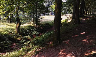
| 20:19, 28 July 2013 | 2,592 × 1,552 (1,582,474 bytes) | w:en:Ethan Doyle White (talk | contribs) | One of the ramparts at [[Blackbury Camp]], [[Devon]], an Iron Age hillfort. Photograph taken in July 2013. |
File history
Click on a date/time to view the file as it appeared at that time.
| Date/Time | Thumbnail | Dimensions | User | Comment | |
|---|---|---|---|---|---|
| current | 16:48, 19 October 2015 | | 2,592 × 1,552 (1.51 MB) | Kelly | Transferred from en.wikipedia: see original upload log above |
File usage
The following file is a duplicate of this file (more details):
- File:Blackbury Camp rampart.jpg from a shared repository
The following page links to this file: