File:Black Middens Bastle - geograph.org.uk - 1224658.jpg
From Wikishire
No higher resolution available.
Black_Middens_Bastle_-_geograph.org.uk_-_1224658.jpg (640 × 480 pixels, file size: 80 KB, MIME type: image/jpeg)
Summary
| Description |
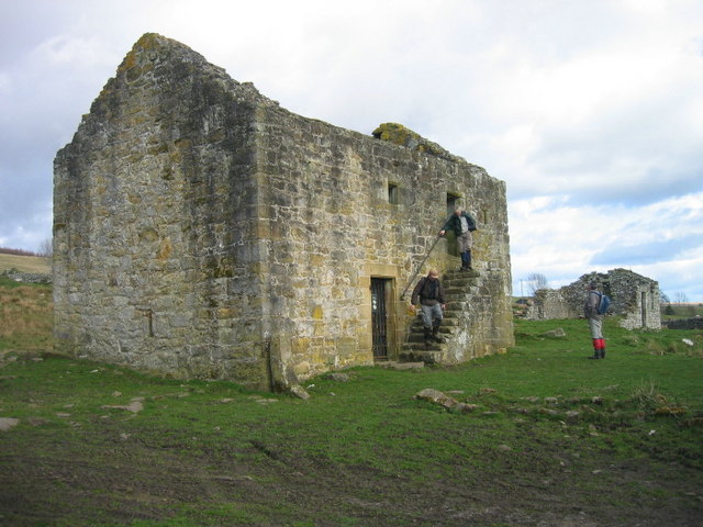
English: Black Middens Bastle Keys to the Past Web Site: This group of buildings at Black Middens includes a well-preserved 16th century bastle, an 18th century farmhouse, traces of a second bastle and a group of enclosures and fields Only the roof is missing from the first bastle and has thick stone walls. The original 16h century doors were replaced in the 18th century. At the same time a new farmhouse was built south-east of the bastle. Little remains of this later farmhouse, but the bastle beneath it survived due to its use as a cattle shed.
http://www.keystothepast.info/durhamcc/K2P.nsf/K2PDetail?readform&PRN=N6990 |
| Date | |
| Source | From geograph.org.uk |
| Author | Les Hull |
| Attribution (required by the license) | Les Hull / Black Middens Bastle / |
| Camera location | | View this and other nearby images on: OpenStreetMap |
|---|
_heading:337.00&language=en)
| Object location | | View this and other nearby images on: OpenStreetMap |
|---|
_heading:337.00&language=en)
Licensing

|
This image was taken from the Geograph project collection. See this photograph's page on the Geograph website for the photographer's contact details. The copyright on this image is owned by Les Hull and is licensed for reuse under the Creative Commons Attribution-ShareAlike 2.0 license.
|
This file is licensed under the Creative Commons Attribution-Share Alike 2.0 Generic license.
Attribution: Les Hull
- You are free:
- to share – to copy, distribute and transmit the work
- to remix – to adapt the work
- Under the following conditions:
- attribution – You must give appropriate credit, provide a link to the license, and indicate if changes were made. You may do so in any reasonable manner, but not in any way that suggests the licensor endorses you or your use.
- share alike – If you remix, transform, or build upon the material, you must distribute your contributions under the same or compatible license as the original.
File history
Click on a date/time to view the file as it appeared at that time.
| Date/Time | Thumbnail | Dimensions | User | Comment | |
|---|---|---|---|---|---|
| current | 09:18, 26 February 2011 | | 640 × 480 (80 KB) | GeographBot | == {{int:filedesc}} == {{Information |description={{en|1=Black Middens Bastle Keys to the Past Web Site: This group of buildings at Black Middens includes a well-preserved 16th century bastle, an 18th century farmhouse, traces of a second bastle and a gro |
File usage
The following file is a duplicate of this file (more details):
- File:Black Middens Bastle - geograph.org.uk - 1224658.jpg from a shared repository
The following page links to this file: