File:Ballymahon Region Within County Longford - Down Survey 1656.jpg
From Wikishire

Size of this preview: 800 × 458 pixels. Other resolution: 320 × 183 pixels.
Original file (1,780 × 1,020 pixels, file size: 765 KB, MIME type: image/jpeg)
Summary
| Description |
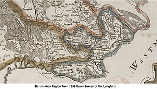
English: Ballymahon Region Within County Longford - Down Survey 1656 |
| Date | |
| Source |
Original publication: 1659 Down Survey |
| Author |
William Petty |
| Camera location | | View this and other nearby images on: OpenStreetMap |
|---|
Licensing
|
This work is in the public domain in its country of origin and other countries and areas where the copyright term is the author's life plus 100 years or fewer. This work is in the public domain in the United States because it was published (or registered with the U.S. Copyright Office) before January 1, 1929. | |
| This file has been identified as being free of known restrictions under copyright law, including all related and neighboring rights. | |
File history
Click on a date/time to view the file as it appeared at that time.
| Date/Time | Thumbnail | Dimensions | User | Comment | |
|---|---|---|---|---|---|
| current | 10:27, 23 November 2016 | | 1,780 × 1,020 (765 KB) | Clancepants | {{subst:Upload marker added by en.wp UW}} {{Information |Description = {{en|Ballymahon Region Within County Longford - Down Survey 1656}} |Source = '''Original publication''': 1659 Down Survey<br/> '''Immediate source''': TCD |Date = 1659 |Author = Wil... |
File usage
The following file is a duplicate of this file (more details):
- File:Ballymahon Region Within County Longford - Down Survey 1656.jpg from a shared repository
The following page links to this file: