File:Aztec West Transport.svg
From Wikishire

Size of this preview: 500 × 500 pixels. Other resolution: 240 × 240 pixels.
Original file (SVG file, nominally 500 × 500 pixels, file size: 20 KB)
| Description |
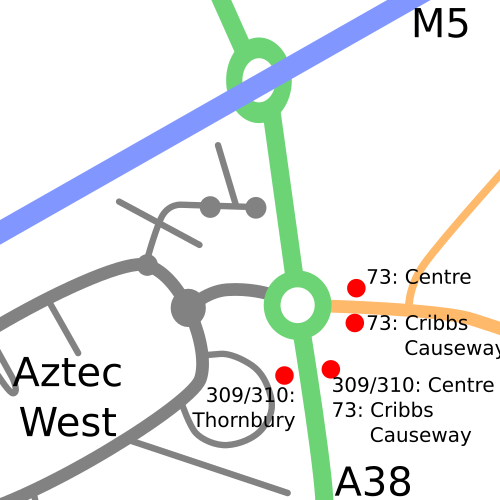
English: A (basic) map detailing public transport links at Aztec West. This W3C-unspecified vector image was created with Inkscape . |
| Date | |
| Source | Own work by uploader, based on data from Openstreetmap |
| Author | Ian13 & Openstreetmap (http://openstreetmap.org) |
|Permission=
This file is licensed under the Creative Commons Attribution-Share Alike 2.0 Generic license.
- You are free:
- to share – to copy, distribute and transmit the work
- to remix – to adapt the work
- Under the following conditions:
- attribution – You must give appropriate credit, provide a link to the license, and indicate if changes were made. You may do so in any reasonable manner, but not in any way that suggests the licensor endorses you or your use.
- share alike – If you remix, transform, or build upon the material, you must distribute your contributions under the same or compatible license as the original.
}}
| Camera location | | View this and other nearby images on: OpenStreetMap |
|---|
File history
Click on a date/time to view the file as it appeared at that time.
| Date/Time | Thumbnail | Dimensions | User | Comment | |
|---|---|---|---|---|---|
| current | 21:04, 2 March 2009 | | 500 × 500 (20 KB) | Ian13 | 73 no longer calls at Aztec West; updating |
File usage
The following file is a duplicate of this file (more details):
- File:Aztec West Transport.svg from a shared repository
The following page links to this file: