File:ArmstrongMap1769DetailRiverGlen.jpg
From Wikishire
No higher resolution available.
ArmstrongMap1769DetailRiverGlen.jpg (557 × 420 pixels, file size: 57 KB, MIME type: image/jpeg)
Summary
| Description |
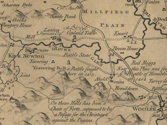
English: A detail from Armstrong's 1769 map of Northumberland showing the course of the River Glen |
| Date | |
| Source | see above |
| Author | Lieutenant Andrew Armstrong & Sons |
Licensing
|
This work is in the public domain in its country of origin and other countries and areas where the copyright term is the author's life plus 100 years or fewer. | |
| This file has been identified as being free of known restrictions under copyright law, including all related and neighboring rights. | |
Original upload log
The original description page was here. All following user names refer to en.wikipedia.
| Date/Time | Dimensions | User | Comment |
|---|---|---|---|
| 2005-06-26 22:08 | 557×420× (58174 bytes) | Nesbit | A detail from Armstrong's 1769 map of Northumberland showing the course of the River Glen {{PD-old}} |
File history
Click on a date/time to view the file as it appeared at that time.
| Date/Time | Thumbnail | Dimensions | User | Comment | |
|---|---|---|---|---|---|
| current | 22:35, 1 June 2018 | | 557 × 420 (57 KB) | Hogweard | Transferred from en.wikipedia via #commonshelper |
File usage
The following file is a duplicate of this file (more details):
- File:ArmstrongMap1769DetailRiverGlen.jpg from a shared repository
The following page links to this file: