File:Angleseymôncloseup.png
From Wikishire
No higher resolution available.
Angleseymôncloseup.png (541 × 522 pixels, file size: 14 KB, MIME type: image/png)
Summary
| Description |
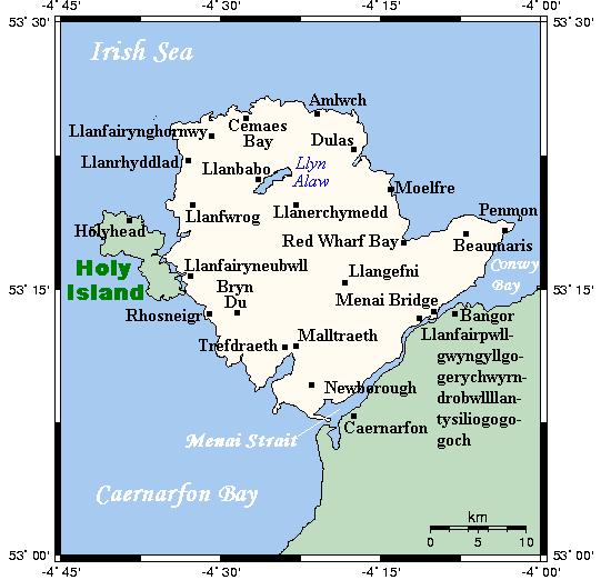
English: A map showing the Isle of Anglesey/Ynys Môn and nearby areas. This map's source is here, with the uploader's modifications, and the GMT homepage says that the tools are released under the GNU General Public License. |
| Date | 10 July 2007 (original upload date) |
| Source | Transferred from en.wikipedia to Commons. |
| Author | Kelisi at English Wikipedia |
Licensing
Kelisi at the English-language Wikipedia, the copyright holder of this work, hereby publishes it under the following license:
| This file is licensed under the Creative Commons Attribution-Share Alike 3.0 Unported license. Subject to disclaimers. | ||
| Attribution: Kelisi at the English-language Wikipedia | ||
| ||
| This licensing tag was added to this file as part of the GFDL licensing update. |

|
Permission is granted to copy, distribute and/or modify this document under the terms of the GNU Free Documentation License, Version 1.2 or any later version published by the Free Software Foundation; with no Invariant Sections, no Front-Cover Texts, and no Back-Cover Texts. A copy of the license is included in the section entitled GNU Free Documentation License. Subject to disclaimers. |
Original upload log
The original description page was here. All following user names refer to en.wikipedia.
- 2007-07-11 16:08 Kelisi 541×522× (14004 bytes) oops again
- 2007-07-10 23:02 Kelisi 542×522× (13753 bytes) oops
- 2007-07-10 22:53 Kelisi 542×522× (13770 bytes) == Summary == A map showing the Isle of Anglesey/Ynys Môn and nearby areas. This map's source is [http://www.aquarius.ifm-geomar.de/ here], with the uploader's modifications, and the [http://gmt.soest.hawaii.edu/ GMT homepage] says that the tools are rel
File history
Click on a date/time to view the file as it appeared at that time.
| Date/Time | Thumbnail | Dimensions | User | Comment | |
|---|---|---|---|---|---|
| current | 15:20, 6 April 2013 | | 541 × 522 (14 KB) | OgreBot | (BOT): Reverting to most recent version before archival |
File usage
The following file is a duplicate of this file (more details):
- File:Angleseymôncloseup.png from a shared repository
The following page links to this file: