File:Ancaster Square, Callander - geograph.org.uk - 218371.jpg
From Wikishire
No higher resolution available.
Ancaster_Square,_Callander_-_geograph.org.uk_-_218371.jpg (640 × 480 pixels, file size: 110 KB, MIME type: image/jpeg)
Summary
| Description |
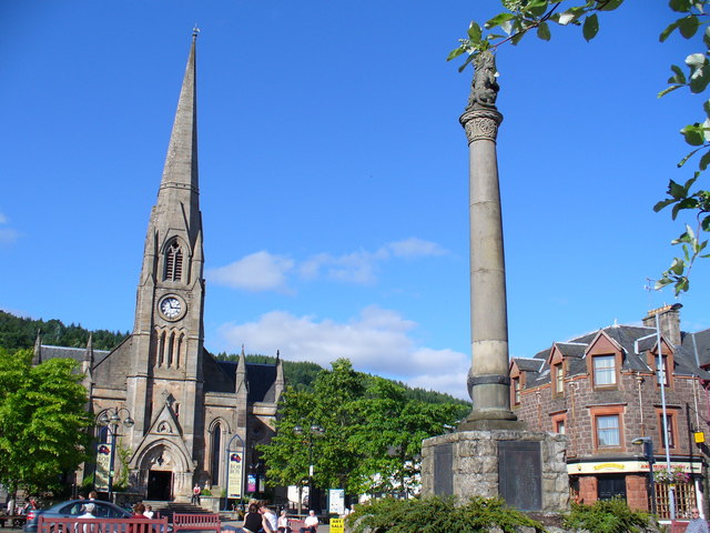
English: Ancaster Square, Callander. Callander was one of Scotland's first planned rural towns - the Duke of Perth plan of ca 1739 has the grid-iron Main Street and neighbouring streets centred on Ancaster Square. The square is named after the former feudal laird, the Earl of Ancaster. The 1883 Gothic church in the northern half of the square was St Kessog's and today it is the Rob Roy / Trossachs Tourist Centre. The war memorial is in the southern half of the square which is bisected by the Main Street. |
| Date | |
| Source | From geograph.org.uk |
| Author | Colin Smith |
| Attribution (required by the license) | Colin Smith / Ancaster Square, Callander / |
| Camera location | | View this and other nearby images on: OpenStreetMap |
|---|
_heading:22.00&language=en)
| Object location | | View this and other nearby images on: OpenStreetMap |
|---|
_heading:22.00&language=en)
Licensing

|
This image was taken from the Geograph project collection. See this photograph's page on the Geograph website for the photographer's contact details. The copyright on this image is owned by Colin Smith and is licensed for reuse under the Creative Commons Attribution-ShareAlike 2.0 license.
|
This file is licensed under the Creative Commons Attribution-Share Alike 2.0 Generic license.
Attribution: Colin Smith
- You are free:
- to share – to copy, distribute and transmit the work
- to remix – to adapt the work
- Under the following conditions:
- attribution – You must give appropriate credit, provide a link to the license, and indicate if changes were made. You may do so in any reasonable manner, but not in any way that suggests the licensor endorses you or your use.
- share alike – If you remix, transform, or build upon the material, you must distribute your contributions under the same or compatible license as the original.
- Remove redundant categories and try to put this image in the most specific category/categories
- Remove this template
- The location categories are based on information from this geonames tool and this OpenStreetMap tool combined with a database. You can also have a look at this tool from mysociety.
- The topic category from Geograph was Square (find similar images at Geograph)
File history
Click on a date/time to view the file as it appeared at that time.
| Date/Time | Thumbnail | Dimensions | User | Comment | |
|---|---|---|---|---|---|
| current | 20:03, 31 January 2010 | | 640 × 480 (110 KB) | GeographBot | == {{int:filedesc}} == {{Information |description={{en|1=Ancaster Square, Callander. Callander was one of Scotland's first planned rural towns - the Duke of Perth plan of ca 1739 has the grid-iron Main Street and neighbouring streets centred on Ancaster S |
File usage
The following file is a duplicate of this file (more details):
- File:Ancaster Square, Callander - geograph.org.uk - 218371.jpg from a shared repository
The following page links to this file: