Yapton
| Yapton | |
| Sussex | |
|---|---|
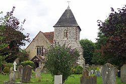
 St Mary, Yapton | |
| Location | |
| Grid reference: | SU979031 |
| Location: | 50°49’12"N, 0°36’40"W |
| Data | |
| Population: | 3,571 (2011) |
| Post town: | Arundel |
| Postcode: | BN18 |
| Dialling code: | 01243 |
| Local Government | |
| Council: | Arun |
| Parliamentary constituency: |
Bognor Regis and Littlehampton |
| Website: | http://www.yaptonpc.gov.uk/ |
Yapton is a village in Sussex, centred three miles north-east of Bognor Regis at the intersection of the B2132 and B2233 roads.
The parish of Yapton lies on the coastal plain south west of Arundel, between the South Downs and the sea. St Mary the Virgin parish church, 13th century or earlier in origin, is in the centre of the village. It houses a twelfth-century font. The village includes Yapton C of E Primary School.
Other settlements in the parish include Bilsham and Flansham. Bilsham Chapel is a deconsecrated former chapel of ease to St Mary the Virgin Church; it dates from the 13th–14th century but fell out of use in the mid-16th century. The building is now a house.[1]
History
- Main article: London to Portsmouth canal
The disused Portsmouth and Arundel Canal which linked nearby the River Arun to Chichester Harbour, runs through the village. This was built primarily on the financial case it would be a safe inland shipping route between London and Portsmouth avoiding the then risk of attack in the English Channel by the French. Throughout its lifetime, 1823-1855 - a time when the Wey and Arun Canal was open (having opened 7 years earlier and having closed in 1871) - the route was used for transporting agricultural goods and munitions, for instance, from Chilworth and Hanworth gunpowder works and to/from the military docks on the lower Thames in Greenwich in Kent.
Outside links
| ("Wikimedia Commons" has material about Yapton) |
- A History of the County of Sussex - Volume 5 : Yapton (Victoria County History)
- Local Heritage Initiative
References
- ↑ A History of the County of Sussex - Volume 5 pp 245-261: Arundel Rape (south-western part including Arundel). Yapton (Victoria County History)