Wye Bridge, Monmouth
| Wye Bridge Welsh: Pont ar Wy | |
| Monmouthshire, Gloucestershire | |
|---|---|
 The Wye Bridge | |
| Location | |
| Carrying: | A466 road |
| Crossing: | River Wye |
| Location | |
| Grid reference: | SO51161276 |
| Location: | 51°48’41"N, 2°42’36"W |
| Structure | |
| Length: | 233 feet |
| Material: | Red and buff sandstone ashlar |
| History | |
| Built 1615–17 1878-80 | |
| Information | |
The Wye Bridge in Monmouth is a bridge across the River Wye, carrying the A466 road over the river between Monmouthshire in the west bank and Gloucestershire on the east. Immediately west of the bridge, the A466 meets the A40. The total span of the bridge is 233 feet.[1]
The bridge is a Grade II listed building.[2]
History
The original wooden bridge was built in the Middle Ages; there is a clear reference to it in the fourteenth century. Earlier references to a bridge at Monmouth may refer either to a bridge over the Wye or to the fortified bridge over the Monnow,[3] although local historian Keith Kissack wrote that the bridge was known to exist in 1282 when it formed a boundary with the Forest of Dean.[4] It was completely rebuilt in stone in the early seventeenth century (1615–17). At that time, tolls were collected from all those crossing the bridge.[3]
A plaque on the parapet records the widening of the bridge on both sides in 1878–80 under the architect Edwin Seward of Cardiff, stating, This bridge was widened 1879 from designs by the County Surveyor, David Roberts Contractor.[5]
The bridge is built of red and buff sandstone ashlar. It has five arched spans with the original pointed arches visible beneath, but with both faces covered by segmental arches carried on the sharply pointed cutwaters.[6]
Routes
The bridge is a crossing for the Wye but it is also the start of the Wysis Way which is a long footpath that connects Monmouth to the Kemble in Gloucestershire and to other National footpaths.
Gallery
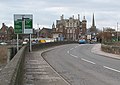
A466 crosses the Wye Bridge, view towards Monmouth School

Close up of an arch of the bridge
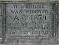
Plaque on the bridge: This bridge was widened in A.D 1879
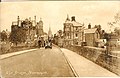
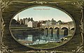
postcard of the Wye Bridge in the 1930s
1910 Postcard depicting the Wye Bridge before 1890 after which the school expanded and demolished the Watermans Arms Public House
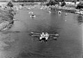
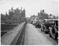
a view of Monmouth raft race from the bridge, 1960s


Outside links
| ("Wikimedia Commons" has material about Wye Bridge, Monmouth) |
References
- ↑ Alan Crow, Bridges on the River Wye, Lapridge Publications, 1995, ISBN 0-9518589-9-8, Page 136
- ↑ Wye Bridge, Monmouth - British Listed Buildings
- ↑ 3.0 3.1 M.L.J. Richards, Monnow Bridge and Gate, Alan Sutton Publishing, 1994, ISBN 0-7509-0415-1, pp.1–2
- ↑ Keith Kissack, Mediæval Monmouth, Monmouth Historical and Educational Trust, 1974, p.33
- ↑ Glamorgan Gwent Archaeological Trust, Historic Landscape Characterisation, Wyesham. Accessed 4 January 2012
- ↑ The Royal Commission on the Ancient and Historical Monuments of Wales, Wye Bridge, Monmouth. Accessed 4 January 2012