Wootton, Staffordshire
From Wikishire
Revision as of 11:17, 19 September 2019 by FixerBot (Talk | contribs) (→About the village: ioe -> nhle, replaced: {{IoE|406072 → {{NHLE|1278308)
| Wootton | |
| Staffordshire | |
|---|---|
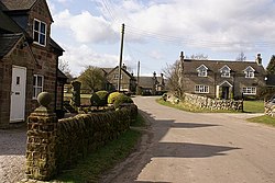
 Stone houses in Wootton | |
| Location | |
| Grid reference: | SK105451 |
| Location: | 53°0’12"N, 1°50’39"W |
| Data | |
| Population: | 154 (2011) |
| Post town: | Ashbourne |
| Postcode: | DE6 |
| Local Government | |
| Parliamentary constituency: |
Staffordshire Moorlands |
Wootton is a village Staffordshire, to be found approximately 20 miles east of Stoke-on-Trent and 20 miles north-west of Derby.
In 1870-72 John Marius Wilson's Imperial Gazetteer described Wootton as:
WOOTTON, a township in Ellastone parish, Stafford; 4½ miles W by S of Ashborne. Real property, £2,061. Pop., 185. Houses, 40. W. Hall was built by Inigo Jones; was the residence of Rousseau in 1766; and belongs now to the Bromleys.[1][2]—Imperial Gazetteer of England and Wales
History
In early reports Wootton was predominately a farming village, with over 60% of men engaged in agriculture.[3][4] Even to this day there remains a large farming culture, with still around 25% of the working population engaged in agriculture.[5] The rest of the population are spread out between working in service industries or in managerial/professional occupations.
About the village
- Wootton Lodge - The privately owned 17th century house is a grade I listed building in the parish. During the Civil War the house was held for the Crown and was badly damaged during a Parliamentary siege. It was restored in about 1700 when a flight of balustraded entrance steps was added.[6]
- Alton Towers - Popular holiday theme park Alton Towers is four miles from Wootton. The resort encloses an area known as "Slain Hollow", reputed to be the site of a battle between King Ceolred of Mercia and King Ina of Wessex in 716 AD.[7]
References
- ↑ History of Wootton in East Staffordshire
- ↑ Wilson, John Marius: Imperial Gazetteer of England and Wales (A. Fullerton & Co., 1870)
- ↑ University of Portsmouth. "Vision of Britain 1881 Census Reports". http://www.visionofbritain.org.uk/census/table_page.jsp?tab_id=EW1881AGE_M10&u_id=10297795&show=DB. Retrieved 27 April 2012.
- ↑ 1881 Census of England and Wales. Tables: Ages, Condition as to Marriage, Occupations and Birthplaces of people, Table 10: " Occupations of Males and Females in the Division and its Registration Counties".. 1883. http://www.visionofbritain.org.uk/census/report_page.jsp?rpt_id=EW1881AGE&show=DB. Retrieved 27 April 2012.
- ↑ Neighbourhood Statistics. "2001 Census: Key Statistics - Parish Profile - Work and Qualifications". http://www.neighbourhood.statistics.gov.uk/dissemination/LeadTableView.do?a=7&b=799425&c=wootton&d=16&e=15&g=485158&i=1001x1003x1004&m=0&r=1&s=1335535873174&enc=1&dsFamilyId=783. Retrieved 27 April 2007.
- ↑ National Heritage List 1278308: Wootton Lodge
- ↑ "Anglo-Saxon Mercia: some facts and some legends". BBC. 16 April 2011. http://www.bbc.co.uk/news/uk-england-stoke-staffordshire-13105212. Retrieved 2 May 2012.