Whitfield, Northamptonshire
| Whitfield | |
| Northamptonshire | |
|---|---|
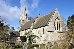
 St John the Evangelist's Church in Whitfield | |
| Location | |
| Grid reference: | SP611387 |
| Location: | 52°2’38"N, 1°6’36"W |
| Data | |
| Population: | 274 (2011) |
| Post town: | Brackley |
| Postcode: | NN13 |
| Dialling code: | 01280 |
| Local Government | |
| Council: | West Northamptonshire |
| Parliamentary constituency: |
South Northamptonshire |
Whitfield is a village in Northamptonshire, in the valley of the Great Ouse, which here forms the border with Buckinghamshire. Nearby villages include Syresham, Biddlesden, Helmdon and Silverstone.
At the time of the 2011 Census, the parish had a population of 274.
The Church of England parish church is dedicated to St John the Evangelist and is a Grade II listed building, built in 1870. The original church, built in the 13th century, was damaged by a heavy gale on 1 February 1869, which blew down the west tower, which required it to be rebuilt entirely.[1]
History
The village's name means simply 'White field'.
Whitfield was a Saxon parish, that was owned by the King at the time of the Domesday Book, in 1086, as part of his manor of King's Sutton. It had a population of 34.[2]
In mediæval times, the parish consisted of a single manor, which belonged to Worcester College, Oxford, who were also the patron of the church.[3]
Outside links
| ("Wikimedia Commons" has material about Whitfield, Northamptonshire) |
References
- ↑ National Heritage List 1190537: Church of St John the Evangelist, Whitfield (Grade II listing)
- ↑ Whitfield, Northamptonshire in the Domesday Book
- ↑ "History of Whitfield". http://www.visionofbritain.org.uk/place/8346.