Weston, Nottinghamshire
From Wikishire
| Weston | |
| Nottinghamshire | |
|---|---|
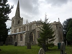
 All Saints Church, Weston | |
| Location | |
| Grid reference: | SK775679 |
| Location: | 53°12’0"N, 0°50’24"W |
| Data | |
| Population: | 393 (2011) |
| Post town: | Newark |
| Postcode: | NG23 |
| Dialling code: | 01636 |
| Local Government | |
| Council: | Newark and Sherwood |
Weston is a village in Nottinghamshire, found ten miles south of Retford. The 2011 census recorded a parish population of 393 (including Grassthorpe).
The parish church, All Saints' Church, is of the 13th century.
At the south-east end of the village are three 16th century tenements built with cruck trusses.[1]
In 1870–72, John Marius Wilson's Imperial Gazetteer of England and Wales described Weston:
- "WESTON, a parish, with a village, in Southwell district, Notts; on the Great Northern railway, 3 miles NNW of Carlton-on-Trent. Post town, Newark. Acres, 1,690. Real property, £2,745. Pop., 380. Houses, 85. The manor belongs to Earl Manvers. The living is a rectory in the diocese of Lincoln. Value, £500. Patron, Earl Manvers. The church was recently repaired, and has a tower and spire. There are a Wesleyan chapel and an endowed school."
| ("Wikimedia Commons" has material about Weston, Nottinghamshire) |
References
- ↑ Nikolaus Pevsner: The Buildings of England: Nottinghamshire, 1951; 1979 Penguin Books ISBN 978-0-300-09636-1