Difference between revisions of "Westbury-on-Severn"
(Created page with "{{Infobox town |county=Gloucester |latitude= 51.8244 |longitude= -2.4124 |picture=High Street, Westbury-on-Severn - geograph.org.uk - 541530.jpg |LG district=Forest of Dean |c...") |
|||
| Line 12: | Line 12: | ||
|os grid ref=SO716140 | |os grid ref=SO716140 | ||
}} | }} | ||
| − | '''Westbury-on-Severn''' is a rural village | + | '''Westbury-on-Severn''' is a rural village and parish in western [[Gloucestershire]], just to the east of the [[Forest of Dean]]. |
==Location== | ==Location== | ||
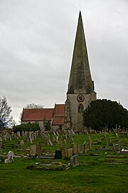
[[File:Tower, Spire and Church of St Peter and St Paul, Westbury-on-Severn.jpg|thumb|180px|Tower, Spire and Church of St Peter and St Paul, Westbury-on-Severn]] | [[File:Tower, Spire and Church of St Peter and St Paul, Westbury-on-Severn.jpg|thumb|180px|Tower, Spire and Church of St Peter and St Paul, Westbury-on-Severn]] | ||
| − | The village is situated on the A48 road (between [[Minsterworth]] and [[Newnham on Severn]]) and bounded by the [[River Severn]] to the south and west. Westbury is also bounded to the west by the Newport to Gloucester railway line, although Westbury does not have a railway station, the closest stations being Gloucester and Lydney. | + | The village is situated on the A48 road (between [[Minsterworth]] and [[Newnham on Severn]]) and bounded by the [[River Severn]] to the south and west. Westbury is also bounded to the west by the [[Newport, Monmouthshire|Newport]] to [[Gloucester]] railway line, although Westbury does not have a railway station, the closest stations being Gloucester and [[Lydney]]. |
Westbury is just over a mile long and has one only housing estate to the south of the main A48 road which was constructed in the 1980s.<ref>{{cite web|last1=Forest of Dean DC.|title=Westbury on Severn Local Plan Review|date=November 2005|page=1}}</ref> The village also has a primary school, post office cum village store, a pub "The Red Lion" and doctor's surgery and dentist surgery. | Westbury is just over a mile long and has one only housing estate to the south of the main A48 road which was constructed in the 1980s.<ref>{{cite web|last1=Forest of Dean DC.|title=Westbury on Severn Local Plan Review|date=November 2005|page=1}}</ref> The village also has a primary school, post office cum village store, a pub "The Red Lion" and doctor's surgery and dentist surgery. | ||
| Line 32: | Line 32: | ||
<references/> | <references/> | ||
| − | == | + | ==Outside links== |
*[http://www.geograph.org.uk/search.php?i=3687652 photos of Westbury-on-Severn and surrounding area on geograph] | *[http://www.geograph.org.uk/search.php?i=3687652 photos of Westbury-on-Severn and surrounding area on geograph] | ||
{{DEFAULTSORT:Westbury-On-Severn}} | {{DEFAULTSORT:Westbury-On-Severn}} | ||
[[Category:Forest of Dean]] | [[Category:Forest of Dean]] | ||
| − | |||
Latest revision as of 12:30, 2 August 2018
| Westbury-on-Severn | |
| Gloucestershire | |
|---|---|

| |
| Location | |
| Grid reference: | SO716140 |
| Location: | 51°49’28"N, 2°24’45"W |
| Data | |
| Population: | 1,792 (2011[1]) |
| Post town: | Westbury-on-Severn |
| Postcode: | GL14 |
| Local Government | |
| Council: | Forest of Dean |
| Parliamentary constituency: |
Forest of Dean |
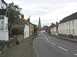
Westbury-on-Severn is a rural village and parish in western Gloucestershire, just to the east of the Forest of Dean.
Location
The village is situated on the A48 road (between Minsterworth and Newnham on Severn) and bounded by the River Severn to the south and west. Westbury is also bounded to the west by the Newport to Gloucester railway line, although Westbury does not have a railway station, the closest stations being Gloucester and Lydney.
Westbury is just over a mile long and has one only housing estate to the south of the main A48 road which was constructed in the 1980s.[2] The village also has a primary school, post office cum village store, a pub "The Red Lion" and doctor's surgery and dentist surgery. Geoff Sterry, a coal and solid fuel merchant, is also based in the village.
The village has a large parish church, which is distinctive, as the steeple is not attached to the main building because of a fire which burned down the old wooden building soon after the new steeple was completed. Within the porch of the church are several markings of crosses and full crosses made during the English Civil War. The north porch and north aisle are the oldest parts of the church, having been built around 1290.[3]
Just to the East of the village centre is the National Trust-owned Westbury Court Garden.
Transport links
The village is served by three regular bus services between Coleford and Gloucester and Lydney and Gloucester.
References
- ↑ "Parish population 2011.Retrieved 28 March 2015". https://neighbourhood.statistics.gov.uk/dissemination/LeadKeyFigures.do?a=7&b=11130427&c=GL14+1ND&d=16&e=62&g=6427371&i=1001x1003x1032x1004&m=0&r=0&s=1427544198051&enc=1.
- ↑ Forest of Dean DC. (November 2005). "Westbury on Severn Local Plan Review". p. 1.
- ↑ Anon. (1992). St Mary, St Peter & St Paul. Westbury-on-Severn, Gloucestershire. p. 1.
