Difference between revisions of "West Moors"
(Created page with "{{Infobox town |name=West Moors |county=Dorset |picture=West Moors Village Centre - geograph.org.uk - 27948.jpg |picture caption=West Moors village centre |os grid ref=SU07902...") |
Motownmickey (Talk | contribs) |
||
| Line 15: | Line 15: | ||
|constituency=Christchurch | |constituency=Christchurch | ||
}} | }} | ||
| − | '''West Moors''' is a village in [[Dorset]] | + | '''West Moors''' is a village in the east of [[Dorset]]. It is found on the northern fringe of the Bournemouth-Christchurch-Poole conurbation, just outside the larger settlements of [[Ferndown]] and [[Verwood]]. |
The parish of West Moors had a recorded population of 7,561 at the 2011 Census. | The parish of West Moors had a recorded population of 7,561 at the 2011 Census. | ||
Revision as of 15:06, 22 May 2022
| West Moors | |
| Dorset | |
|---|---|
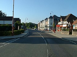
 West Moors village centre | |
| Location | |
| Grid reference: | SU079027 |
| Location: | 50°49’26"N, 1°53’19"W |
| Data | |
| Population: | 7,561 (2011) |
| Post town: | Ferndown |
| Postcode: | BH22 |
| Dialling code: | 01202 |
| Local Government | |
| Council: | Dorset |
| Parliamentary constituency: |
Christchurch |
West Moors is a village in the east of Dorset. It is found on the northern fringe of the Bournemouth-Christchurch-Poole conurbation, just outside the larger settlements of Ferndown and Verwood.
The parish of West Moors had a recorded population of 7,561 at the 2011 Census.
West Moors rose to local prominence with the building of the Southampton and Dorchester and Salisbury and Dorset Junction railway lines in the late 19th century and although main line services were later diverted via Bournemouth, West Moors railway station was served by a branch line railway until 4 May 1964. The only remnants of these lines through the village are the original level crossing gatekeeper's cottage on Station Road, and the Castleman Trailway footpath following the original trackbed leading to Ringwood in Hampshire to the east and Poole to the west. This 'rail-trail' was recently resurfaced and the central reservation was removed, rendering the southernmost of the two tracks largely unusable, and causing it to lose its former authentic look.
The village expanded with the development of the military fuel depot located outside the village but within the parish. The depot is home to the Defence School of Petroleum, and also to the Dorset Fire and Rescue Service Training Centre. In April 2017 the Royal Air Force relocated their Fuels Training school from RAF Halton to MOD West Moors. In July 2018 it was announced that after over 80 years the Military would move from West Moors, under project Wellsley the RAF would relocate to MoD Worthy Down in January 2019 and the Army would have moved by April 2020. In the past many military families were housed in their own housing estates, however most jobs are now undertaken by civilian personnel and the military housing sold off. More recent population increases have been due to the influx of commuters, both to Bournemouth and Poole, and to more remote destinations such as Southampton, and London.
West Moors has a mixed population, with a relatively high proportion of elderly people. There are two first schools, one middle school, two youth clubs; including a scout group, and a skatepark.
Society and sport
There are various shops including one butcher, one baker and two pubs. There is also the West Moors Social Club which has entertainment nights. Moors Valley Country Park is three miles from the village, and is easily accessible from the Castleman Trailway.
The village's sports facilities include two football pitches (Fryers Playing Field). The tennis courts have recently been refurbished into an artificial floodlit grass football facility and a multi-use area that can be used as two tennis courts or other sports. There is also a playpark on Fryer’s field and on the other side of the village (Shaftesbury Road) there is another slighter smaller play park.
Outside links
| ("Wikimedia Commons" has material about West Moors) |