Walsoken
| Walsoken | |
| Norfolk | |
|---|---|
 Parish church of All Saints, Walsoken | |
| Location | |
| Grid reference: | TF4710 |
| Location: | 52°40’19"N, 0°11’22"E |
| Data | |
| Post town: | Wisbech |
| Postcode: | PE14 |
| Dialling code: | 01945 |
| Local Government | |
| Council: | Fenland / King's Lynn and West Norfolk |
| Parliamentary constituency: |
Fenland South West Norfolk |
Walsoken is a village in Norfolk at the edge of the Cambridgeshire town of Wisbech, into which it is largely merged as a suburb. The village is a mile east of Wisbech town centre, 13½ miles west of King's Lynn and 56 miles west of Norwich.
The county boundary runs through the townscape of Wisbech dividing Walsoken from Wisbech. Walsoken straddles the route of the B198 (which was the old A47 renumbered in 1984 with the opening of the Wisbech bypass).
The civil parish of Walsoken, which represents the eastern parts of the village that have escaped the swelling of Wisbech, had a recorded population of 1,484 in 2001.
The name Walsoken is thought to originate from the Old English meaning the soke (district under particular jurisdiction) by the wall[1] which may refer to the village's proximity to a Roman sea wall or defence.
Contents
Description
Much of the ancient character and historic core of Walsoken have been lost under modern housing.
The nearest railway station is at Downham Market for the Fen Line which runs between King's Lynn and Cambridge. The nearest airport is Norwich International Airport.
All Saints Parish Church
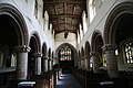
All Saints' Church in Walsoken is a Grade I Listed Building and consists of a nave with south and north aisles, chancel with south and north chapels, south porch The nave and chancel are both late Norman and date from c.1146.[2] Above the chancel arch is a 15th-century carving of King David with harp.
This church is crowned by a prominent west tower with four turrets and a spire which dates from the mediæval period.[3] To the base of the tower is the rounded Norman west doorway. The interior of the church has massive Norman arcades which are rich with zigzag moulding decoration. An arch in the chancel is supported on carved banded shafts. On one side is the 15th-century doorway to the old rood loft. The nave roof has painted angels and other figures in delicately canopied niches. There are 15th-century[2] screens in both aisles, one with most intricate tracery, stalls with carved heads, battered figures on old benches, and over the tower arch two paintings of the judgement of Solomon with a statue of a king enthroned between them. The Seven Sacrament font is 400 years plus old.[3] This pre-Reformation font is decorated with sculptures of the crucifixion and seven sacraments (these are; Baptism, Confession, Confirmation, Last Rites, Mass, Matrimony and Ordination), eight saints under rich canopies (these are; Catherine, Paul, John, Magdala, Steven, Margaret, Peter and Dorothea), and round the base this inscription to those friends of the church who gave it: "Remember the souls of S. Honyter and Margaret his wife, and John Benforth, Chaplain 1544".[3] One child baptised at this font grew up to be Archbishop of Canterbury. He was the Rector's boy, Thomas Herring, who became Archbishop in 1747,[3] and a little while before he died put a tablet in the chancel here "in grateful memory of his excellent parents". He was a man of immense enthusiasm and full of generosity. There are several later window insertions throughout.
The church's bell tower has six bells made by Thomas Osborn in Downham Market in 1795. Originally the bells were hung in a frame adjacent to the louvres in the tower. The bells were restored and re-hung in 1901 by the children of Richard Young, MP for North Cambridgeshire, and further work was undertaken in 1956 when the bells were re-hung in a lower position in the tower in an eight bell metal frame. This was to allow for the future provision of two additional bells which has not to date been achieved.
Pictures
The arch chancel supported on carved banded shafts
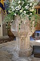
The 400 year old font
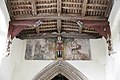
The nave roof with painted angels and other figures


History
Roman Settlement
Archaeological evidence has found that much of the land of Walsoken of pre-Roman occupation was completely submerged beneath the Iron Age silts. As such, very little early prehistoric archaeology has been recorded. It is thought that some dry land existed within the parish in the Bronze Age as several artefacts from that time period were uncovered in the 19th century. There has been a lot more archaeological evidence found to attest to Roman occupation in the parish, including a dispersed hoard of 300 to 400 Roman coins, mostly of Postumus, but including examples minted by Gallienus and Hostilian which were found via metal detecting in the 1980s.
Norman period
Walsoken was established by the time of the Norman Conquest. The villages population, land ownership and productive resources were detailed in its entry in the Domesday Book of 1085. It records Walsoken by the name Walsocam. The parish was held by the Benedictine Order based at Ramsey Abbey before and after 1066. The survey also records the presence of a fishery.
Outside links
| ("Wikimedia Commons" has material about Walsoken) |
References
- ↑ A Popular Guide to Norfolk Place-names: by James Rye: Published by Larks press, Dereham, Norfolk, 2000 ; ISBN 0-948400-15-3
- ↑ 2.0 2.1 Norfolk 2: Norfolk: North-west and South, By Nikolaus Pevsner and Bill Wilson, Walsoken entry. 0-300-09657-7
- ↑ 3.0 3.1 3.2 3.3 The King's England series, NORFOLK, by Arthur Mee,Pub:Hodder and Stoughton,1972, page 323/324, Walsoken, ISBN 0-340-15061-0