Walkinstown
| Walkinstown Irish: Baile Bhailcín | |
| County Dublin | |
|---|---|
 Walkinstown | |
| Location | |
| Grid reference: | O104318 |
| Location: | 53°19’32"N, 6°20’35"W |
| Data | |
| Population: | 6,819 (2016) |
| Postcode: | D12 |
| Local Government | |
| Council: | Dublin City Council |
| Dáil constituency: |
Dublin South-Central |
Walkinstown is a suburb of Dublin, in County Dublin, on the Southside of the city, approximately four miles south-west of Dublin city centre. It borders Crumlin to the east, Drimnagh to the north, Greenhills to the south and Ballymount and Clondalkin to the west.
Walkinstown is a suburb consisting primarily of privately owned residential housing with some social housing remaining in the Dublin City Council area between the Walkinstown and Long Mile Roads and Ballymount Lower. It was built as an estate of starter homes after World War 2 with the council housing being developed as social rented homes later in the early to mid fifties.
Light industry, warehousing, car dealerships and commercial outlet stores are concentrated along the Long Mile Road in the western sector of the suburb. The 2016 census recorded a population of 6,819. The area is very well served with a library, residents' association, sports ground, community centre, schools, pubs, church and retail facilities.
Name and History
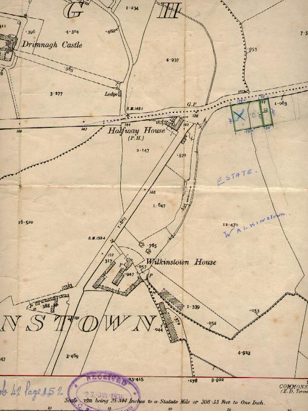
The name of the area is a corruption of Wilkinstown - named after Wilkins, a tenant farmer who lived in the area in the 15th century. The Irish name for the area is 'Baile Bhailcín'.
Walkinstown as a suburb is a 20th-century creation. The area was a dairy farm until house building began in the 1930s. Building ended in the area in the 1970s when most of the available land was built upon. The 1950s saw the building of the local Catholic church as well as primary and second schools for boys and girl.
About Walkinstown
The local Roman Catholic Church, Our Lady of the Assumption, is one of the largest buildings in the village, standing on Kilnamanagh Road.
Walkinstown Park is a Dublin City Council run park, on the Walkinstown Avenue opposite Lidl. The park has three football pitches and two GAA pitches. It also has a tennis court and a stream that runs at the rear of the park.
There are a few local historic landmarks within the area of Walkinstown. One of the oldest buildings in the immediate vicinity is Drimnagh Castle, located on the northern side of the Long Mile Road. This castle dates from 1216 and is the only castle in Ireland with a flooded moat.
The Halfway House pub is the oldest public house in the area, predating all of the housing developments that went to make up the suburb.[1] This pub, which used to be a Coachhouse, situated halfway between Dublin and Tallaght, retains the outward appearance of the country pub, although the interior was recently modernised. The most distinctive buildings of the Walkinstown area are that of the local Catholic church and schools, built in a sturdy style of the 1950s with red brick and green copper roofing and impressive stained glass windows, made by local craftsmen.
An area of Walkinstown north of Cromwellsfort Road is known as the Musical Roads. Roads in this area are named after prominent figures of Irish music - examples include the tenor Count John McCormack and composers Michael William Balfe, Percy French and Edward Bunting.
The SuperValu supermarket on Walkinstown Road was once the site of Walkinstown House, a distinctive country house and the family home of the Flanagan family, including the infamous "The Bird Flanagan", a well-known Dublin character and infamous practical joker of the early 20th century. It is said that The Long Mile Road was named after a mile long horse race along this route won by the Bird Flanagan. However it was later argued that it was a long mile.[2]
Sport
- Gaelic Athletics: St James Gaels GAA
- Football:
- Walkinstown Athletic FC
- Walkinstown United FC[3]
- Athletics: Walkinstown Sports and Athletic Association
Mooney's Field, the local name given to the largest green open space in the Walkinstown area (situated on Bunting Road), is used for many field sports. The nearest municipal swimming pool is located in Crumlin village.
Society
- The 94th Dublin Scout Den is situated on Bunting Road.
Outside links
- Walkinstown Association
- Walkinstown United Football Club
- Drimnagh Castle Boys Secondary School
- Assumption Girls National School Walkinstown
- 94th Walkinstown Scouts