Difference between revisions of "Walbury Hill"
m |
|||
| Line 1: | Line 1: | ||
{{Infobox hill | {{Infobox hill | ||
|name=Walbury Hill | |name=Walbury Hill | ||
| − | |county=Berkshire | + | |county 1=Hampshire |
| + | |county 2=Berkshire | ||
|picture=The South Western Slopes of Walbury Hill - geograph.org.uk - 62332.jpg | |picture=The South Western Slopes of Walbury Hill - geograph.org.uk - 62332.jpg | ||
|picture caption=The South Western Slopes of Walbury Hill | |picture caption=The South Western Slopes of Walbury Hill | ||
| Line 8: | Line 9: | ||
|os grid ref=SU373616 | |os grid ref=SU373616 | ||
}} | }} | ||
| − | '''Walbury Hill''' is the | + | '''Walbury Hill''' is a broad, round hill on the border of [[Berkshire]] with [[Hampshire]], on which are the [[county top|highest points]] of both counties. the hilltop was reshaped in ages past to serve as a hillfort, Walbury Camp, whose earthen fortifications remain impressive. |
| − | + | A long-distance footpath runs across the hill, known as the Wayfarer's Walk or the Test Way: eastward into Hampshire it is the Wayfarer's Walk and westward into Berkshire the Test Way. The path marks the county boundary and beyond the hill to either side it follows the immemorial ridge of the Downs, giving a fine view out from the chalk escarpment down over the farms of Berkshire. | |
| − | + | The hill's true summit is at 974 feet above sea level and is marked by a triangulation pillar about 100 yards from the main Test Way within a private field. This point is in Hampshire and is that county's highest point. The county top of Berkshire is just below it on the Wayfarer's Walk. | |
| − | + | Beyond Walbury Hill, the Wayfarer's Walk definitively enters Hampshire, climbing up to Hampshire's second hill, [[Pilot Hill]], just a mile and a half away. | |
| − | Walbury Hill is | + | Walbury Hill is to be found south of the scattered Berkshire village of [[Inkpen]] and 5 miles southeast of [[Hungerford]], the closest town. |
| − | The hill is the | + | The top of the hill is an Iron Age hill fort known as '''Walbury Camp'''. |
| + | |||
| + | [[Combe Gibbet]] stands on the adjoining [[Gallows Down]], names suggesting a dark history. | ||
| + | |||
| + | Walbury Hill is also reckoned to be the highest point all of southeastern Britain, though this is disputed by [[Leith Hill]] in [[Surrey]] (which, subject to detailed measurement, may be ten feet below in as to its natural height, though higher when the Leith Hill tower is measured). | ||
| + | |||
| + | Walbury Hill is sometimes used by the [[BBC]] as a temporary relay station during major sporting events. There is also a small low level circular brick building, approximately 6 feet high, on the south side of the hill. This appears to be a disused reservoir. No metalled road passes across the hill, but the byway is open to all traffic and maintained with a hard gravel surface, probably because of its use by outside broadcast vehicles. The ridged summit is also popular with paragliding enthusiasts. | ||
==Pictures== | ==Pictures== | ||
<center><gallery> | <center><gallery> | ||
| − | File:Walbury Hill - geograph.org.uk - 1895.jpg|View to the west with | + | File:Walbury Hill - geograph.org.uk - 1895.jpg|View to the west with Combe Gibbet centre top on the skyline |
File:View from Walbury Hill.jpg|The view from Walbury Hill, looking towards Combe Gibbet | File:View from Walbury Hill.jpg|The view from Walbury Hill, looking towards Combe Gibbet | ||
File:View over Southern Berkshire from Walbury Hill Car Park - geograph.org.uk - 171532.jpg|View over Southern Berkshire from Walbury Hill Car Park | File:View over Southern Berkshire from Walbury Hill Car Park - geograph.org.uk - 171532.jpg|View over Southern Berkshire from Walbury Hill Car Park | ||
| Line 28: | Line 35: | ||
</gallery></center> | </gallery></center> | ||
| − | {{Commons | + | {{Commons}} |
[[Category:County tops]] | [[Category:County tops]] | ||
Revision as of 09:46, 31 May 2012
| Walbury Hill | |
| Hampshire, Berkshire | |
|---|---|
 The South Western Slopes of Walbury Hill | |
| Summit: | 974 feet SU373616 |
Walbury Hill is a broad, round hill on the border of Berkshire with Hampshire, on which are the highest points of both counties. the hilltop was reshaped in ages past to serve as a hillfort, Walbury Camp, whose earthen fortifications remain impressive.
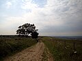
A long-distance footpath runs across the hill, known as the Wayfarer's Walk or the Test Way: eastward into Hampshire it is the Wayfarer's Walk and westward into Berkshire the Test Way. The path marks the county boundary and beyond the hill to either side it follows the immemorial ridge of the Downs, giving a fine view out from the chalk escarpment down over the farms of Berkshire.
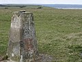
The hill's true summit is at 974 feet above sea level and is marked by a triangulation pillar about 100 yards from the main Test Way within a private field. This point is in Hampshire and is that county's highest point. The county top of Berkshire is just below it on the Wayfarer's Walk.
Beyond Walbury Hill, the Wayfarer's Walk definitively enters Hampshire, climbing up to Hampshire's second hill, Pilot Hill, just a mile and a half away.
Walbury Hill is to be found south of the scattered Berkshire village of Inkpen and 5 miles southeast of Hungerford, the closest town.
The top of the hill is an Iron Age hill fort known as Walbury Camp.
Combe Gibbet stands on the adjoining Gallows Down, names suggesting a dark history.
Walbury Hill is also reckoned to be the highest point all of southeastern Britain, though this is disputed by Leith Hill in Surrey (which, subject to detailed measurement, may be ten feet below in as to its natural height, though higher when the Leith Hill tower is measured).
Walbury Hill is sometimes used by the BBC as a temporary relay station during major sporting events. There is also a small low level circular brick building, approximately 6 feet high, on the south side of the hill. This appears to be a disused reservoir. No metalled road passes across the hill, but the byway is open to all traffic and maintained with a hard gravel surface, probably because of its use by outside broadcast vehicles. The ridged summit is also popular with paragliding enthusiasts.
Pictures
View to the west with Combe Gibbet centre top on the skyline
The view from Walbury Hill, looking towards Combe Gibbet
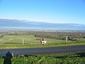
View over Southern Berkshire from Walbury Hill Car Park
Looking across the crest of the hill towards the area of the longbarrow


| ("Wikimedia Commons" has material about Walbury Hill) |