Valentia Island
| Valentia Island Irish: Dairbhre | |
 Knightstown Town clock | |
|---|---|
| Main village: | Knightstown |
| Location | |
|
| |
| Location: | 51°54’34"N, 10°21’1"W |
| Grid reference: | V383756 |
| Area: | 6,371 acres |
| Highest point: | Geokaun, 873 feet |
| Data | |
| Population: | 665 (2011) |

Valentia Island is one of Ireland's most westerly points. It lies off the Iveragh Peninsula in the south-west of County Kerry. It is linked to the mainland by the Maurice O'Neill Memorial Bridge at Portmagee. A car ferry also departs from Reenard Point to Knightstown, the island's main village, from April to October. A second, smaller village named Chapeltown is located at roughly the midpoint of the island, two miles from the bridge. The permanent population of the island is 665 according to the 2011 Census.
The island about seven miles long by almost two miles wide.
Contents
Name
The name of the island in Irish is Dairbhre, meaning "The Oak Wood".
The English name 'Valentia Island' derives form that of a village on the island called An Bhaile Inse ('town of the island') or Beal Inse ("mouth of the island" or "island in the mouth of the sound"). The name has also been written as 'Valencia Island' as if it were after the Spanish city of that name and familiarity with the Spanish name might have influenced the rendering of the name here.
History

Foilhommerum on the island is the site of the first permanent communications link between the British Isles (and thence Europe) and the Americas, laid from here to Heart's Content in Newfoundland. A monument to this achievement stands atop Foilhommerum Cliff.
In 1866, Valentia was the eastern terminus of the first commercially viable transatlantic telegraph cable.[1] The first attempt in 1857[2] to land a cable from Ballycarbery Strand on the mainland just east of Valentia Island ended in disappointment. After subsequent failures of cables landed at Knightstown in 1858 and Foilhommerum Bay in 1865. In 1866 however the vast endeavour finally resulted in commercially viable transatlantic telegraph communications from Foilhommerum Bay to Heart's Content in Newfoundland. Transatlantic telegraph cables operated from Valentia Island for one hundred years, ending with Western Union International terminating its cable operations in 1966.
Until the transatlantic telegraph, American longitude measurements had a 2,800-foot uncertainty with respect to European longitudes. Because of the importance of accurate longitudes to safe navigation, the United States Coast Survey mounted a longitude expedition in 1866 to link longitudes in the United States accurately to the Royal Observatory in Greenwich. Benjamin Gould and his partner A. T. Mosman reached Valentia on 2 October 1866. They built a temporary longitude observatory beside the Foilhommerum Cable Station to support synchronized longitude observations with Heart's Content, Newfoundland. After many rainy and cloudy days, the first transatlantic longitude signals were exchanged between Foilhommerum and Heart's Content on 24 October 1866.
On 21 May 1927, Charles A. Lindbergh made his first landfall in Europe over Dingle Bay and Valentia Island on his solo flight from New York to Paris. On the 1927 Mercator chart used by the famous pilot, it was labelled 'Valencia'.[3]
Dinosaurs
In 1993 an undergraduate geology student discovered fossilised tetrapod trackways, footprints preserved in Devonian rocks, on the north coast of the island at Dohilla (51°55’51"N, 10°20’38"W). About 385 million years ago, a primitive vertebrate passed near a river margin in the sub-equatorial river basin that is now south-western Ireland and left prints in the damp sand. The prints were preserved by silt and sand overlying them, and were converted to rock over geological time. The Valentia Island trackways are among the oldest signs of vertebrate life on land.[4][5]
Places of interest

The combined features and history of the island make it an attractive tourist destination, easily accessible from the popular Ring of Kerry route.
- Geokaun Mountain and Fogher Cliffs: the highest hill on Valentia Island and the sea cliffs of 600 feet on its northern face.
- On the northeast of the island stands Glanleam House amid sub-tropical gardens. Protected by windbreaks from Atlantic gales and never touched by frost, these gardens provide the mildest microclimate in Ireland. Starting in the 1830s, Sir Peter George Fitzgerald, the 19th Knight of Kerry (1808–1880), planted these gardens and stocked them with a unique collection of rare and tender plants from the southern hemisphere, normally grown under glass in Ireland. The gardens are laid out in a naturalistic style as a series of walks. There are plants from South America, Australia, New Zealand (the tallest tree ferns in Europe), Chile and Japan. The gardens are memorialized in a selected golden-variegated Luma apiculata "Glanleam Gold" that originated as a sport in the garden. The gardens are open to the public.
- The slate quarry which reopened in 1998 provided slates for the Palace of Westminster.
- The island heritage centre tells the story of the geology, human, natural and industrial history of the island, with exhibits on the Cable Station, the Marine Radio Station and the RNLI's Valentia Lifeboat Station.
- The Telegraph Field (or Longitude Field) is the site of the first permanent communications link between Europe and North America Transatlantic telegraph cables operated from Valentia Island from 1866.
Pictures
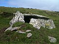
Dolmen Rock, western slope of Mt. Geokaun
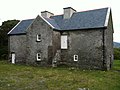
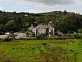
Balleyhearney House, Balleyhearney East. 'Famine Era' hospital adjacent to the Knights' Wood.
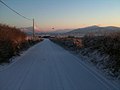
Rare snowy day, Main Road, Valentia Island looking toward Knightstown, Valentia Harbour and Cahersiveen
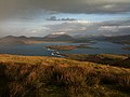
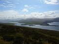
Portion of the view from the summit of Mt. Geokaun ("yo-kawn"). Valentia Harbour and Cahersiveen are in the background
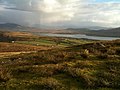
Portion of the view from the summit of Mt. Geokaun ("yo-kawn"). Valentia Harbour and Letter are in the background
View from Culloo Rock. Dingle Peninsula, Dingle Bay and the north shore of Valentia Island (including Fogher Cliffs) are in the background.
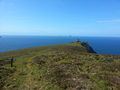
Bray Head view looking west with Skellig Islands in distance
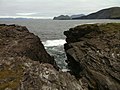
View of Portmagee Channel looking south-east from Bray Head
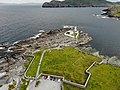
Valentia lighthouse and surrounding fortifications

Knightstown
Glanleam House
Valentia Slate Quarry


Sport
- Gaelic sports: Valentia Young Islanders GAA
Valentia is a popular fishing location, and Valentia waters hold the Irish records for conger eel, red sea bream, Ray's bream and lesser spotted dogfish.
Outside links
| ("Wikimedia Commons" has material about Valentia Island) |
- Valentia Island
- Valentia Heritage Centre
- Valentia Island Annual Music Festival
- Valentia Island Sea Angling
- Irelandbyways site Valentia Information
References
- ↑ The Atlantic Cable, Smithsonian Institution, USA.
- ↑ John R. Isaac, 1857 — Laying the Atlantic Telegraph Cable from Ship to Shore, History of the Atlantic Cable & Undersea Communications.
- ↑ Hampton, Dan (2017). The flight : Charles Lindbergh's daring and immortal 1927 Transatlantic crossing (First ed.). New York, NY: HarperCollins. p. 189. ISBN 978-0-06-246439-2. OCLC 957504448.
- ↑ Stössel, Iwan; Williams, Edward A.; Higgs, Kenneth T. (15 November 2016). "Ichnology and depositional environment of the Middle Devonian Valentia Island tetrapod trackways, south-west Ireland" (in en). Palaeogeography, Palaeoclimatology, Palaeoecology 462: 16–40. doi:10.1016/j.palaeo.2016.08.033. SSN 0031-0182.
- ↑ Niedźwiedzki, Grzegorz; Szrek, Piotr; Narkiewicz, Katarzyna; Narkiewicz, Marek; Ahlberg, Per E. (January 2010). "Tetrapod trackways from the early Middle Devonian period of Poland" (in en). Nature 463 (7277): 43–48. doi:10.1038/nature08623. SSN 1476-4687. PMID 20054388.
- Travel Information
- The Tetrapod Trackways
- The Atlantic Cable (Valentia Heritage Centre):
- Cable History
- Alan Hall - Sculptor of the First Transatlantic Cable and First message sent to USA 1856 Memorial
- Submarine Telegraphs, Their History, Construction, and Working by Charles Bright
Further reading
- Browne, E.T., The fauna and flora of Valencia Harbour on the west coast of Ireland. Proc. R.Ir. Acad., ser.3,5, 667-854
- The Transatlantic Longitude as Determined by the Coast Survey Expedition of 1866