Upton Cheyney
From Wikishire
Revision as of 20:45, 7 December 2019 by RB (Talk | contribs) (Created page with "{{Infobox town |name=Upton Cheyney |county=Gloucestershire |picture=Brewery Hill - geograph.org.uk - 357023.jpg |picture caption=Brewery Hill, Upton Cheyney |os grid ref=ST692...")
| Upton Cheyney | |
| Gloucestershire | |
|---|---|
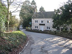
 Brewery Hill, Upton Cheyney | |
| Location | |
| Grid reference: | ST692699 |
| Location: | 51°25’37"N, 2°26’35"W |
| Data | |
| Postcode: | BS30 |
| Local Government | |
| Council: | South Gloucestershire |
Upton Cheyney is a village in the very south of Gloucestershire, just half a mile east of Bitton, the county’s southernmost village, and a few hundred yards north of the Somerset border.
To the north-east is the swelling conurbation of Bristol, overspilling the border of the two counties itself, and to the south-east is Bath, in Somerset.
Outside links
| ("Wikimedia Commons" has material about Upton Cheyney) |