Upton, Slough
| Upton | |
| Buckinghamshire | |
|---|---|
 St. Laurence, Upton | |
| Location | |
| Grid reference: | SU979792 |
| Location: | 51°30’13"N, 0°35’27"W |
| Data | |
| Post town: | Slough |
| Postcode: | SL1 |
| Dialling code: | 01753 |
| Local Government | |
| Council: | Slough |
| Parliamentary constituency: |
Slough |
Upton is a suburb of Slough in Buckinghamshire. Upton was one of the villages that developed into the town, and indeed Slough itself was once a mere hamlet of the parish of Upton-cum-Chalvey. The village stands in the south of Slough, contiguous with the town and centred around its parish church. It has been developed along with Slough and is barely to be distinguished from it.
Upton takes its name from its position at the top of the slope from the river terrace.
Church
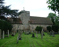
Upton's Norman Church, St Laurence's Church, is around 900 years old.
This was the church at which Sir William Herschel was married (on 7 May 1788) where he lies buried (1822). In his memory the church has a stained-glass window depicting Uranus, which he discovered, and other planets). Charles Hatchett who discovered niobium lied here too.
Secular buildings
Parts of Upton Court were built in 1325. In the 19th century, it was a seat of the Burton family and was, up until March 2010, home to the Slough Observer newspaper.
A 19th-century half-timbered building called "The Mere", built in 1887 by the grandson of Richard Bentley, is now the head office of the National Foundation for Educational Research. Long Close School was established in the area in 1940.
Upton Park
Upton Park forms one of Slough's earliest planned estates. Laid out in 1842, the grounds (a public park as Herschel Park since 1949) are believed to have been designed by Joseph Paxton.[1]
Outside links
- Page, William (ed) (1925). Victoria County History of Buckinghamshire. Vol. 3. pp. 314–318. http://www.british-history.ac.uk/report.aspx?compid=42565.
References
- ↑ p 144, The History of Slough, Maxwell Fraser, Slough Corporation, Slough, 1973