Upton, Dorset
| Upton | |
| Dorset | |
|---|---|
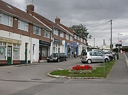
 Shops at Upton | |
| Location | |
| Grid reference: | SY978932 |
| Location: | 50°44’18"N, 2°1’44"W |
| Data | |
| Post town: | Poole |
| Postcode: | BH16 |
| Dialling code: | 01202 |
| Local Government | |
| Council: | Dorset |
| Parliamentary constituency: |
Mid Dorset and North Poole |
Upton is a town in south east Dorset, immediately west of Poole and north of Hamworthy, to which it is joined. To the south is Lytchett Bay, a little tidal inlet which opens into Poole Harbour.
The town is built around a road junction where the Blandford to Hamworthy road crosses the main Poole to Dorchester road. The Poole suburbs of Hamworthy and Turlin Moor adjoin to the south, and Lytchett Minster village lies a short distance to the west.
Although mostly residential, Upton features a small industrial estate with businesses including Southernprint.
About the village
In 2000, The Upton Clock Tower was built at the Upton Crossroads to celebrate the new millennium and represent the town pride.
The town is bounded by several areas of open space. To the north, Upton Heath is a 'Site of Special Scientific Interest',[1].
To the east, Upton Wood[2] and the former estate Upton Country Park separate the town from Holes Bay.
Lytchett Bay south of the village is part of Poole Harbour SSSI.[3]
Churches
- Church of England: St Dunstan's, built in 1991, replacing an older church on the same site.
- Methodist: Upton Methodist Church's Wesleyan Chapel was built in 1865,[4]
Outside links
| ("Wikimedia Commons" has material about Upton, Dorset) |
- Dorset County Council: Lytchett Minster/Upton
- Lytchett Minster and St Dunstans's Churches
- Memories of Upton - Upton Millennium Project
- LUCA Website - Lytchett Minster and Upton Community Association
References
- ↑ SSSI listing and designation for Upton Heath
- ↑ "Upton Wood". DorsetForYou.com. https://www.dorsetforyou.gov.uk/uptonwood. Retrieved 9 April 2017.
- ↑ SSSI listing and designation for Poole Harbour
- ↑ "Important news and notice of forthcoming events!". Upton Methodist Church. http://uptonmethodistchurch.net/news.php. Retrieved 18 April 2017.