Uckerby
| Uckerby | |
| Yorkshire North Riding | |
|---|---|
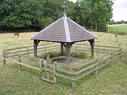
 St. Cuthbert's Well, Uckerby | |
| Location | |
| Grid reference: | NZ245022 |
| Location: | 54°24’56"N, 1°37’22"W |
| Data | |
| Post town: | Richmond |
| Postcode: | DL10 |
| Local Government | |
| Council: | North Yorkshire |
Uckerby is a hamlet in the North Riding of Yorkshire, at a crossroads on the road between Scorton and Moulton, nine miles north-west of Northallerton.
History
Uckerby first appears on record as Ukerby, in 1198. The name is derived from two Old Norse elements: the first is thought to be an unattested Old Norse personal name, either *Úkyrri or *Útkári; the second element is býr, meaning farmstead.[1][2]
In the 13th century, the land was held as part of the FitzAlan fee of the manor of Catterick, with the tenants having the same name as the hamlet. The manor had passed to Andrew de Harcla, Earl of Carlisle by the start of the next century, but had to be forfeited when he was defeated in the rebellion against Edward II. The manor then became the possession of the Scrope family of Bolton and followed the descent of the manor of Ellerton-on-Swale until its sale around 1734 to Henry Foster. It was briefly held by James Riddell and his son from 1777 to around 1872 before being bought once again by the lord of the manor of Ellerton-on-Swale.[3][4]
Outside links
| ("Wikimedia Commons" has material about Uckerby) |
References
- ↑ Watts (2011). Cambridge Dictionary of English Place-names. Cambridge University Press. p. 635. ISBN 978-0521168557.
- ↑ Mills, Anthony David: 'A Dictionary of British Place-Names' (Oxford University Press, 2003) ISBN 978-0-19-852758-9
- ↑ A History of the County of York: North Riding - Volume 1 pp pp301-313: Parishes: Catterick (Victoria County History)
- ↑ Bulmer's Topography, History and Directory (Private and Commercial) of North Yorkshire 1890. S&N Publishing. 1890. p. 377. ISBN 1-86150-299-0.