Ubley
| Ubley | |
| Somerset | |
|---|---|
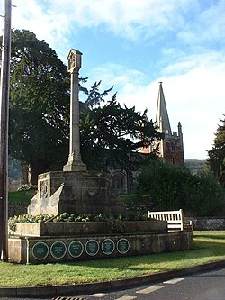
 Ubley Cross and church tower | |
| Location | |
| Grid reference: | ST529582 |
| Location: | 51°19’15"N, 2°40’31"W |
| Data | |
| Population: | 331 (2011) |
| Post town: | Bristol |
| Postcode: | BS40 |
| Dialling code: | 01761 |
| Local Government | |
| Council: | Bath & NE Somerset |
| Parliamentary constituency: |
North East Somerset |
Ubley is a small village within the Chew Valley in Somerset about eight miles south of Bristol and ten miles from Bath. It is just south-east of Blagdon Lake on the A368 between Compton Martin and Blagdon.
The parish is part of the Chewton Hundred.[1]
Contents
Parish church
The village has a small mediæval church, the Church of St Bartholomew originating from the 13th century with later additions. The church has no fixed pews. Features include a Jacobean pulpit and a chained copy of the 'Paraphrases of Erasmus' dated 1552.[2] The church is a Grade I listed building.[3]
History
There is some evidence of a burial tumulus from neolithic times above Ubley.[4]
In a charter of King Edgar, between 959 and 975 the name of the village was recorded as Hubbanlege.[5]
Ubley is listed in the Domesday Book of 1086 as Tumbeli, meaning 'The rolling meadow' from the Old English tumb and leah.[6] An alternative explanation is that it comes from Ubba's leah or clearing in the woodland.
Mining for ochre and manganese took place during the 19th century.[7]
Geography
The village lies under the northern slopes of the Mendip Hills within the Chew Valley about 8 miles south of Bristol and 10 miles from Bath. It is just south-east of Blagdon Lake and between Blagdon Lake and Chew Valley Lake.
About the village
There are four Grade II listed buildings in the village:
- National Heritage List 1320718: Mendip View
- National Heritage List 1129653: Methodist Church
- National Heritage List 1320717: The Manor House
- National Heritage List 1129655: K6 Telephone Kiosk
Society
The modern village hall is the venue for Rainbow Guides on a Monday during term time as well as the monthly Ubley Publey and annual Chew Valley Beer Festival.
Outside links
| ("Wikimedia Commons" has material about Ubley) |
- Area 4 – Mendip Slopes: BANES Environmental Services
- Map of Ubley circa 1900
References
- ↑ "Somerset Hundreds". GENUKI. http://www.genuki.org.uk/big/eng/SOM/Miscellaneous/. Retrieved 8 October 2011.
- ↑ Nikolaus Pevsner: Pevsner Architectural Guides
- ↑ National Heritage List 1129654: Church of St Bartholomew
- ↑ "Mendip: An Archaeological Survey of the Area of Outstanding Natural Beauty". Somerset County Council Archeological Projects. http://www.somerset.gov.uk/media/896B4/MendipAONB.pdf. Retrieved 28 October 2006.
- ↑ Havinden, Michael. The Somerset Landscape. The making of the English landscape. London: Hodder and Stoughton. p. 85. ISBN 0-340-20116-9.
- ↑ Robinson, Stephen (1992). Somerset Place Names. Wimborne, Dorset: The Dovecote Press Ltd. ISBN 1-874336-03-2.
- ↑ Gough, J.W. (1967). The mines of Mendip. Newton Abbot, Devon: David & Charles. https://www.amazon.co.uk/o/ASIN/B0000CNKWB.
