Trefriw
| Trefriw | |
| Caernarfonshire | |
|---|---|
 Trefriw | |
| Location | |
| Grid reference: | SH780632 |
| Location: | 53°9’6"N, 3°49’28"W |
| Data | |
| Population: | 1,338 (2001) |
| Post town: | Conwy |
| Postcode: | LL27 |
| Dialling code: | 01492 |
| Local Government | |
| Council: | Conwy |
| Parliamentary constituency: |
Aberconwy |
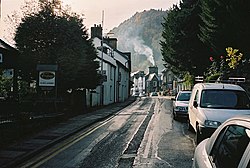
Trefriw is a village in Caernarfonshire. It stands on the River Conwy, a few miles south of the site of the Roman fort of Canovium, sited at Caerhun. The parish population in 2001 was 924.
Trefriw lies on the edge of Snowdonia, on the B5106 road to the north-west of Llanrwst, and about 4½ miles north of Betws-y-coed by road, on the western slopes of the Conwy Valley, below the ridge of Cefn Cyfarwydd.
The village is largely built in a semicircle at the point where the River Crafnant flows from its hanging valley to join the river Conwy. The river Crafnant still provides power for the woollen mill, and in the past provided power for a number of other industries based along its banks, such as a forge which provided quarry tools.
Most of the village lies within the Snowdonia National Park, the boundary of which runs down the main street of the village.
Contents
The village
Trefriw is a pretty village, standing beneath the romantic tree-clad hills on the Western side of the River Conwy. The best view over the village is on the eastern side of the dale, enjoying the graceful curve of the Crafnant Valley, which forms a charming background. A visitor may wander from the village into the forested hills and lose himself amongst the trees, leaving the bustle of life far behind, the mountains of the Carneddau climbing to their own lonely heights above.
Trefriw grew when visitors began to head for Caernarfonshire for vigorous holidays, and it still caters well for such holidaymakers. Its heyday was the Edwardian period, a time of restrained good taste, and it remains little altered from those days.
Apart from its reputation as a good starting point for walks, Trefriw is today mostly known for its woollen mills, and for the nearby chalybeate spa, first known to have been used by the Romans and further developed in about 1700. Its waters were one of very few throughout Europe to have been classified as a medicine due to their high iron content.
Name of the village
The name of Trefriw is from Tref Rhiw Las; the name Tref Rhiw is normally rendered "Town of the Hill". Llywelyn Fawr donated a number of farms from the parish of Llanrhychwyn, naming them as the parish of Tref Rhiw Las, a name from the slope on which it stood.[1]
The information board in the village opts instead for a meaning derived from the healing waters; "Wound Town" ("briw" means "wound").
Over the centuries the spelling of the name Trefriw has seen numerous versions. While Llywelyn named the new parish "Tref Rhiw Las", a document of 1254 refers to the place as Treffruu.[2] and a number of documents from the 16th century refer to Treverewe, Treffrewe, Treverow and Treffrew (as well as to Trefriw), with Trefriew appearing on a document of 1795.[3]
At the lower (northern) end of the village is a brook named "Ffrwd Gwenwyn y Meirch", meaning "poison the horses stream". The local belief is said that the stream was poisoned by Prince Llywelyn at a time of war, resulting in the deaths of many horses. The Red Book of Hergest (1375–1425) refers to "Kymwt Treffryw", the Commote of Trefriw. This is possibly the earliest written reference to the village.
History
The Romans
A major Roman road (Sarn Helen) ran southwards through Trefriw from the fort at Caerhun (between Trefriw and Conwy) to the fort at Tomen-y-mur (near Trawsfynydd), and beyond, ultimately reaching Moridunum at Carmarthen. It is likely that two roads passed through the valley by Trefriw but this can only be conjecture today.[4]
The Middle Ages
Llywelyn Fawr built a hunting lodge here in the 12th century, in a spot outside the village of Llanrhychwyn which became Trefriw, and it is reported that he preferred his lodge at Trefriw to his Palace at Abergwyngregyn. Nothing remains today but it is believed that the hunting lodge was on the site of the Ebenezer Chapel on the main hill. Llywelyn's wife, Joan, the youngest daughter of King John of England, grew weary of the trek up the steep hill to the church at Llanrhychwyn and as a result, in about 1230 Llywelyn endowed a church on the site where St Mary's, Trefriw now stands, and created the parish of Tref Rhiw Las.
Early modern period
It seems probable that Trefriw has links with the Gunpowder Plot of 1605. Thomas Wiliems, who was probably born in the village, and a nephew of Sir John Wynn of Gwydir, practiced in Trefriw as a physician. He published a Welsh-Latin dictionary, and in 1573 he became Curate of Trefriw. However is reputed to have been a papist and was certainly charged as such at Bangor in 1607. According to some sources, it was Willems who warned his relative John Wynn not to go to the State Opening of Parliament on 5 November 1605, which warning led to the discovery of the Gunpowder Plot. This story is the basis for a short historical novel written for children by Gweneth Lilly, entitled Treason at Trefriw (Gomer Press, 1993).
The parish of Trefriw was owned for a long period by the Gwydir Estate (although under continuous mortgage), but in 1895–96 most of Llanrhychwyn and Trefriw were sold off by the Barons Willoughby de Eresby and the Earls of Ancaster.
The 19th Century
In 1817 a free school was founded and financially supported in Trefriw by Lord Willoughby de Eresby, for the benefit of poor children of the village, and those from the adjoining parishes.
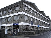
The earliest mill (a fulling mill) dates back to the 15th century. In 1820 a new mill was built; the "Vale of Conwy Woollen Mill". By early in the 19th century the village had a water-powered fulling mill (replacing the former cottage industry which dated back centuries), but serious development of the industry began only after it was bought by Thomas Williams in 1859. The current woollen mill is still owned by the descendants of Thomas Williams. The current roadside mill building, sited below the original buildings, was built in the 1970s.
Port town
In the 19th century Trefriw was the largest inland port in Wales, as the River Conwy was tidal up to neighbouring Llanrwst.
At the start of the 19th century, boats of around 5 tons could only reach Trefriw quay at or near high tides. The quay belonged to the Gwydir Estate and was ruled by a resident harbourmaster; it was later extended (the present structure dates from about 1811–12), and became of great significance to Trefriw, its growth, and subsequent history. Subsequent rock blasting in the 19th century downstream at Tal-y-cafn, and dredging, enabled river boats of 50 tons and sea-going ships of 100 tons to reach Trefriw. The quays were sited opposite the Bellevue Hotel, now the Princes Arms Hotel, and remains can still be seen, best viewed from the walks on 'the Cob'.
From the quay was shipped out grain, wool, hide, oak, timber and metals from the mines of the Gwydir Forest. A considerable amount of slate was also shipped, quarried from Trefriw Quarry and up Cwm Penmachno and the slopes to the north of Blaenau Ffestiniog in Merionethshire.[5] The quay went into terminal decline though later in the century as alternative routes opened up, not least the Ffestiniog Railway at Blaenau Ffestiniog.
In the early 19th century up to 450 vessels traded from the quay, to places such as Liverpool and Dublin. Trade totalled 1,548 tons in 1818, and peaked in 1862 at a total of 16,532 tons, after which the railways contributed to the decline of trade via the quays. In 1854 the main quay acquired a weighing machine and a crane, and there was a small shipyard in the village. Sulphur was shipped from the Cae Coch Sulphur Mine,[6] before the railway line was built.[7]
There were smaller quays further down the river, with the Gwydir Estate owning Coed Gwydir (for stone) and Cae Coch (sulphur). Below this, other non-Gwydir quays were at The Abbey (Maenan), Porth Llwyd (Dolgarrog) and Tal-y-cafn, but Trefriw saw the most trade, by far.
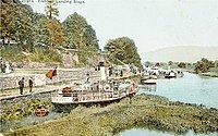
Until 1939 the quay was used by paddle steamers which brought tourists up the river from Conwy. The start of the 20th century saw some five steamers plying the route, and carrying a total of over 1,000 passengers.
The steamers were laid up in Second World War, and this spelled the end of the cruises, other than a brief couple of seasons in the 1950s when motor boats were used - at 5/- (25p) return. The steamers were beached upstream of Conway bridges, and eventually scrapped. Their passage up the river had necessitated regular river-dredging, which has no longer been continued.
The Victorian and Edwardian periods
The latter 19th century a number of artists settled in Trefriw. From Betws-y-coed in the 1850s, there was a movement down the valley, and the 1881 census recorded 9 artists living in the village.[8] The bustle they created ultimately drove the artists away to Tal-y-bont and Llanbedr-y-cennin.
In 1833 the old Roman mineral water caves (believed to have been discovered by soldiers of the XXth Roman Legion) were excavated in an attempt to attract people to them. In 1863 Lord Willoughby de Eresby built a small bath-house, replaced a decade later by the current building. Large numbers of people came, no doubt aided by national advertising, and the declaration by Dr. Hayward, a fashionable medical specialist from Liverpool, that this was "Probably the best spa in the United Kingdom". Baddeley's guidebook notes contains the quote - "inconceivably nasty and correspondingly efficaceous". In more recent times clinical trials have proven that the Spa water is a medically effective iron supplement.[9] For over a century the Spa was open as a tourist attraction, but in 2011 it was closed to the public, and serves today only as a commercial business.
In 1879, Morris Jones wrote (translated):[1]
| “ | Regarding the village itself, its position is such that germs cannot live in it - every part of it is on a self-purifying slope - its pure and balmy air, and its beautiful aspect, it receives the healthiest greetings of the morning sun, so that it fully justifies its title - the healthiest place in Wales. | ” |
Further credence was given to this belief when it became known that Mary Owen, Britain's oldest woman (see above), was born in Trefriw.
The village once had a 9-hole golf course, on land between Cowlyd Road and Crafnant Road, on the slopes uphill of the cemetery. It was laid out in 1893 on land owned by Lord Ancaster (who owned much land in the area) by Thomas Dutton (of the Belle View Hotel), who naturally gave discounts to hotel residents. The course was never really successful, and after closure (by 1918) the clubhouse was transferred to the quay.
The village was at its heyday in the early part of the 20th century, visitors arriving by both train and steamer. Many visitors to the Spa arrived by train to Llanrwst station, which opened in the 1860s. From here transport was provided, over Gower's bridge, named after the Revd John Gower, rector of Trefriw, who came to Trefriw in 1869 (from Queen's College, Birmingham), and lived in the grand rectory, built in 1842, and located up School Bank Hill. There was a toll of 1d for pedestrians and 2d for cyclists, this money being used to finance the building of the road. The original toll bridge had about 10 wooden piers, and was wide enough to take a horse and carriage. It was demolished in the 1940s after the Council, having bought the road, agreed to spend £1,500 on the present suspension bridge. The original toll house, Gower's House, was also demolished, but remains of its site can still be seen.
Churches
- Church in Wales: St Mary's
- Ebenezer Chapel
- The Peniel Chapel
Sights about the village
The Fairy Falls
The Fairy Falls, a waterfall on the river Crafnant, was a popular visiting place. Downstream of the main falls are a number of further, lesser, falls, which old postcards also call the "Fairy Falls". Along this lower section of river the water once turned a number of waterwheels which powered various mills.
The whole area of this series of falls, from the main falls through the lesser falls downstream, is known as "Fairy Glen", and was altogether more free from trees and vegetation than it is today. In Edwardian times there was a proper path alongside the river Crafnant, and a popular stroll was to walk from the banks of the river Crafnant, up through the Fairy Glen, and on beside the river Crafnant up towards Llyn Crafnant.[10]
Floods
Trefriw is on the edge of the flood plain of River Conwy and subjected to flooding on occasion. On various occasions in the 20th century defences have been built and improved, including the partial diverting of the Afon Crafnant, which itself carries a lot of water from the Crafnant catchment area.
in February 2004, following a period of prolonged rain in the mountain catchment areas of the river Conwy and its tributaries, the village was largely cut off by floods for three days, and some properties on the lower High Street were flooded by three feet of water.[11][12] The following January saw a repeat occurrence, and sections of the Cob were again breached.[13]
The Environment Agency have now completed work on the new cob which now runs through Glyn Farm Caravan site and the recreational ground. Both pieces of land have undergone significant changes to accommodate the new cob. This work was undertaken after the environment agency arranged a detailed mapping of the valley, with the aim of moving the cob further back in order to give a wider "channel".
Buildings of Trefriw
- The Princes Arms Hotel, built about 1846. In 1930 The Belle View Spa rooms were opened, so that tourists could sample the Spa waters in the village itself, the Spa being a mile to the north.
- The Fairy Falls public house was originally the Geirionnydd Vaults
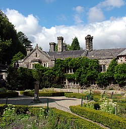
- Hafod Country House: the oldest house in the village, confirmed to be of Mediæval origin.[14] It was built as a hall house, with a solar and a tower which followed a pattern used in the castles of the 13th century hereabouts.
- Gwyndy Cottage: reputedly the second-oldest house in Trefriw; parts date back to the 16th century.
- "Tan yr Yw" ("Under the Yew"), the home of Dafydd Jones, an 18th-century poet and printer.
- Tyddyn Wilym, the home of Gwilym Cowlyd, the bard, born in 1828. Gwilym believed that the house was also the former birthplace of Dr Thomas Wiliems, who allegedly played an unwitting part in revealing the Gunpowder Plot.
- Plas Cae Coch" ("Red Field Hall"), from the mid 1800s. In 1841 it was the home of Robert and Elizabeth Hill, the operators of the Cae Coch Sulphur Mine.
Glanrafon stores was built at the end of the 19th century, replacing some former cottages. The top floors once operated as the Glanrafon Private Hotel and Boarding House.
References
- ↑ 1.0 1.1 Jones, Morris: Hanes Trefriw
- ↑ http://www.gwp.enta.net/walhist.html
- ↑ Melville Richards Archive Place-Name Database
- ↑ Cantrell, J & Rylance, A: Sarn Helen (Cicerone Press, 1992)
- ↑ Rhiw Bach Quarry
- ↑ Subterranea Britannica: Sites: Cae Coch Sulphur Mine
- ↑ John Bennett & Robert W Vernon: The Mines of The Gwydir Forest. vol 7. (Gwydir Mines Publications, 1997)
- ↑ Ellis, T: Artists in the Conwy Valley, 2010
- ↑ Research - Spatone - Nelsons UK
- ↑ Mortimer Hart, K: The Conwy Valley, 1987 ISBN 0 86381 087
- ↑ BBC NEWS | UK | Wales | North West Wales | Anger over flood warnings
- ↑ BBC NEWS | UK | Wales | North West Wales | Flood warnings 'not good enough'
- ↑ BBC NEWS | UK | Wales | Flood victims' six-month wait
- ↑ BBC Making History Website
Outside links
- Trefriw Village website
- Large Postcard Collection of Trefriw
- Trefriw Tourist Association website
- Trefriw Trails
- Princes Arms Hotel
- The Old Ship / Yr Hen Long
- Fairy Falls Hotel
- Gwydir Castle
- Trefriw Wells Spa
- Trefriw Woollen Mills
- GENUKI Genealogy site : Trefriw
- Rhiwbach Quarry and the Rhiwbach Tramway
- Geograph.co.uk photos of Trefriw and surrounding area
Books
- The Conwy Valley & the lands of history, by K. Mortimer Hart (pub Gwasg Carreg Gwalch, 1987)
- 'The Conwy Valley – Its Long History, by Michael Senior (pub Gwasg Carreg Gwalch, 1984)
- Hanes Trefriw, by Morris Jones (pub W.J. Roberts, 1879)
- Sarn Helen, by J. Cantrell & A. Rylance (pub Cicerone Press, 1992)

