Totnes
| Totnes | |
| Devon | |
|---|---|
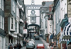 The Eastgate over the High Street in 1983 | |
| Location | |
| Grid reference: | SX805605 |
| Location: | 50°25’55"N, 3°41’2"W |
| Data | |
| Population: | 7,444 (2001) |
| Post town: | Totnes |
| Postcode: | TQ9 |
| Dialling code: | 01803 |
| Local Government | |
| Council: | South Hams |
| Parliamentary constituency: |
Totnes |
Totnes is a pretty market town tumbling down the hill to the head of the estuary of the River Dart in eastern Devon. It is about 22 miles south of the city of Exeter.
Totnes has a long recorded history, dating back to 907 when its first castle was built. It was already an important market town by the 12th century. Indications of its former wealth and importance are given by the number of merchants' houses built in the 16th and 17th centuries.
Today, the town, is a thriving centre for music, art, theatre and natural health. It has a sizeable alternative and "New Age" community, and is known as a place for the bohemian lifestyle.[1]
Contents
The lie of the land
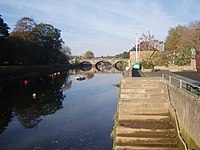
The town is built on a hill rising from the west bank of the River Dart, which separates Totnes from the suburb of Bridgetown. It is at the lowest bridging point of the river which here is tidal and forms a winding estuary down to the sea at Dartmouth. The river continues to be tidal for about a mile above the town, the tidal limt being Totnes Weir, built in the 17th century.
Today there are two road bridges, a railway bridge and a footbridge over the river in the town. Totnes Bridge is the nearest bridge to the sea and is a road bridge built in 1826–28 by Charles Fowler.[2] At low tide the foundations of the previous stone bridge are visible just upstream—it was probably built in the early 13th century and widened in 1692. Before the first stone bridge was built there was almost certainly a wooden bridge here, and a tidal ford for heavy vehicles was just downstream.[3] In 1982 a new concrete bridge was built about 1,000 feet upstream as part of the Totnes inner relief road. Its name, Brutus Bridge, was chosen by the local residents.[4] Half a mile upstream, the railway bridge carries the Exeter to Plymouth railway line over the river. Immediately upstream of the railway bridge is a footbridge, built in 1993 to provide access to the Totnes (Littlehempston) terminus of the South Devon Railway.[5]
Name of the town
The name Totnes is first recorded in 979 as Tottanæs and is Old English for Totta's headland.[6] Before reclamation and development, the low-lying areas around this hill were largely marsh or tidal wetland, giving the hill much more the appearance of a "ness" than today.
Legend of the Brutus Stone
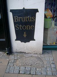
In Geoffrey of Monmouth's wildly imaginative work Historia Regum Britanniae (The History of the Knig's of Britain" c. 1136), it was to "the coast of Totnes" that Brutus of Troy landed in Britain and became its founder.[7] Set into the pavement of Fore Street is the 'Brutus Stone', a small granite boulder onto which, according to local legend, Brutus first stepped from his ship. As he did so, he was supposed to have declaimed:[8]Here I stand and here I rest. And this town shall be called Totnes.
That the stone is far above the highest of tides need not worry the romantic imagination nor that the tradition is likely to be relatively recent; it is first mentioned in John Prince's Worthies of Devon in 1697.[8]
It is possible that the Brutus Stone was originally the one from which the town crier, or bruiter called his bruit or news; or it may be le Brodestone, a boundary stone mentioned in several 15th century disputes: its last-known position in 1471 was below the East Gate.[8]
History
The first authenticated history of Totnes is in 907, when it was fortified by King Edward the Elder as part of the defensive ring of burhs built around Devon, replacing one built a few years earlier at nearby Halwell.[9] The site was chosen because it was on an ancient trackway which forded the river at low tide.[9] Between the reigns of Edgar and William II (959–1100) Totnes intermittently minted coins.[10]
At some time between the Norman Conquest and the compilation of the Domesday Book, William the Conqueror granted the burh to Juhel of Totnes, who was probably responsible for the first construction of the castle. Juhel did not retain his lordship for long, however, as he was deprived of his lands in 1088 or 1089, for rebelling against William II.[10]
By the 12th century, Totnes was already an important market town, due to its position on one of the main roads of the South West, in conjunction with its easy access to its hinterland and the easy navigation of the River Dart.[11]
Modern history
By 1523, according to a tax assessment, Totnes was the second richest town in Devon, and the sixteenth richest in England, ahead of Worcester, Gloucester and Lincoln.[9]
In 1553, King Edward VI granted Totnes a charter granting the former Benedictine priory building that had been founded in 1088 for use as Totnes Guildhall and a school. In 1624, the Guildhall was converted to be a magistrate's court. Soldiers were billeted here during the Civil War and Oliver Cromwell visited for discussions with the general and parliamentary commander-in-chief Thomas Fairfax, 3rd Lord Fairfax of Cameron in 1646.[12] Until 1887, the Guildhall was also used as the town prison with the addition of prison cells.[13] It remained a magistrate's court until 1974.
Economy
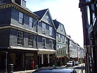
The town has a wide variety of local shops, for the most part running down the steep High Street and Fore Street. The town council has been keen to ensure a variety of shops and to avoid its becoming a "clone town": in 2012 Totness gained national headlines when a local "No to Costa" campaign successfully prevented Costa Coffee from opening a branch in the town.[14]
The great majority of the shops in Totnes are local shops to serve the townsfolk and the crowds of visitors which come in the summer. Totnes has also attracted a sizeable "alternative" community with a "New Age" outlook.[15] There are a number of facilities for artists, painters and musicians, and there is a twice-weekly market offering antiques, musical instruments, second-hand books, handmade clothing from across the world, and local organically producedproducts. In 2007, Time magazine declared Totnes the capital of new age chic.
In March 2007 Totnes was the first town in Britain to introduce its own local alternative currency, the Totnes pound, to support the local economy of the town.[16] Fourteen months later, 70 businesses within the town were trading in the "Totnes pound," accepting them as payment and offering them to shoppers as change from their purchases.[16] The initiative is part of the "Transition Towns" concept, which was pioneered by Rob Hopkins, who had recently moved to Totnes.[17]
Emphasising the town's continuing history of boatbuilding, between 1998 and 2001 Pete Goss built his revolutionary but ill-fated 120-foot Team Philips catamaran there.[18]
Loss of revenue from Dartington College of Arts (which has moved to Falmouth) has been partially offset by increased tourism due to interest in Totnes's status as a transition town.[19]
Parish chrch
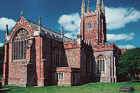
The parish church is St Mary's; a late mediæval church with a high west tower, 120 feet tall and visible from afar. It is built of rich red Devonian sandstone.
Totnes Castle
The imposing circular keep of Totnes Castle stands at the top of the town. It is now owned by English Heritage. It has a motte-and-bailey in the typical Normn style.
The catle was built during the reign of William I, probably by Juhel of Totnes.[2]
Landmarks
Totnes is said to have more listed buildings per head than any other town.
A prominent feature of the town is the Eastgate—an arch spanning the middle of the main street. This Elizabethan entrance to the walled town was destroyed in a fire in September 1990, but was rebuilt.[20]
The ancient Leechwell, so named because of the supposed medicinal properties of its water, and apparently where lepers once came to wash, still provides fresh water.
The Butterwalk is a Tudor covered walkway that was built to protect the dairy products once sold here from the sun and rain.[21]
Totnes Elizabethan House Museum is in one of the many authentic Elizabethan merchant's houses in the town, built around 1575.[22]
Outside links
| ("Wikimedia Commons" has material about Totnes) |
References
- ↑ Edwards, Adam (10 Nov 2007). "Property in Totnes: Wizards of the wacky West". The Daily Telegraph. http://www.telegraph.co.uk/property/3359800/Property-in-Totnes-Wizards-of-the-wacky-West.html. Retrieved 2009-08-15.
- ↑ 2.0 2.1 Bridget Cherry & Nikolaus Pevsner (1989). The Buildings of England — Devon. Harmondsworth: Penguin. pp. 866–875. ISBN 0-14-071050-7.
- ↑ Russell, Percy (1984). The Good Town of Totnes (Second impression with Introduction ed.). Exeter: The Devonshire Association. pp. 26.
- ↑ Russell 1984, p.xv.
- ↑ Taylor, Alan; Treglown, Peter (May 1999). South Devon Railway - A Visitors Guide. South Devon Railway Trust. pp. 23–28.
- ↑ Ekwall, Eilert (1960). The Concise Oxford Dictionary of English Place-names (4th ed.). Oxford [Eng.]: OUP. pp. 478. ISBN 0-19-869103-3.
- ↑ Brown, Theo (1955). "The Trojans in Devon". Report & Transactions of the Devonshire Association 87: 63.
- ↑ 8.0 8.1 8.2 Brown, Theo (1955). "The Trojans in Devon". Report & Transactions of the Devonshire Association 87: 68–69.
- ↑ 9.0 9.1 9.2 Stansbury, Don (1998). "907–1523: The king's town". in Bridge, Maureen. The Heart of Totnes. Tavistock: AQ & DJ Publications. pp. 123–131. ISBN 0-904066-36-3.
- ↑ 10.0 10.1 Hoskins, W. G. (1954). A New Survey of England: Devon. London: Collins. pp. 504–508.
- ↑ Kowaleski, Maryanne (1992). "The port towns of fourteenth-century Devon". in Duffy, Michael, et al.. The New Maritime History of Devon; Volume 1: From early times to the late eighteenth century. London: Conway Maritime Press. pp. 63. ISBN 0-85177-611-6.
- ↑ Totnes Guildhall, Whatsonwhen.
- ↑ Totnes Guildhall, Visit Britain, UK.
- ↑ Costa Coffee pulls out of Totnes despite planning approval - BBC News, 25 October 2012.
- ↑ Siegle, Lucy (2005-05-08). "Shiny hippy people". The Guardian. http://lifeandhealth.guardian.co.uk/experts/story/0,,1623868,00.html. Retrieved 2008-07-02.
- ↑ 16.0 16.1 Sharp, Rob (1 May 2008). "They don't just shop local in Totnes - they have their very own currency". The Independent. http://www.independent.co.uk/news/uk/this-britain/they-dont-just-shop-local-in-totnes--they-have-their-very-own-currency-818586.html. Retrieved 2008-07-02.
- ↑ "Take note - Totnes will be quids in!" in Totnes Times 7 March 2007, p.6
- ↑ "Team Philips wreckage found on island". BBC Devon News. Wednesday 23 January 2002. http://www.bbc.co.uk/devon/news/012002/23/team_philips.shtml. Retrieved 2009-08-16.
- ↑ Town's Transition boosting economy (retrieved 30 November 2010)
- ↑ Iconic arch rebuilt after devastating 1990 fire
- ↑ "Totnes Town Trail". South Devon Area Of Outstanding Natural Beauty. http://www.southdevonaonb.org.uk/sitedetails.asp?PageId=32&SiteId=854. Retrieved 2008-07-02.
- ↑ "Totnes Elizabethan House Museum". Devon Museums Group. http://www.devonmuseums.net/component/option,com_mumancontent/task,view/sectionid,23/. Retrieved 2008-07-02.
