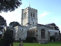
Toddington, Bedfordshire
| Toddington | |
| Bedfordshire | |
|---|---|
 St George, Toddington | |
| Location | |
| Grid reference: | TL009289 |
| Location: | 51°57’0"N, 0°31’48"W |
| Data | |
| Population: | 4,459 (2001) |
| Post town: | Dunstable |
| Postcode: | LU5 |
| Dialling code: | 01525 |
| Local Government | |
| Council: | Central Bedfordshire |
| Parliamentary constituency: |
Mid Bedfordshire |
Toddington is a large village and parish in Bedfordshire, five miles north of Luton, four miles north of Dunstable and six miles south-west of Woburn. The hamlet of Fancott also forms part of the Toddington civil parish.
The village is on the A5120 and B579 and just half a mile from Junction 12 of the M1 motorway, where it lends its name to the Toddington Services.
It is situated near the motorway and many larger towns, however is built around a large village green, on which sits the parish church and four of the village's six public houses.
Many of the population commute to London for work by rail from Harlington and Leagrave stations. Toddington has experienced a rise in house prices due to its reputation as a quiet village and the easy commute into London.
Toddington is on a chalky plateau known as Totternhoe Stone, which rises up to 100 feet above the other villages hereabouts. The Icknield Way Path passes through the village.
Churches
There are five churches:
- Church of England:
- St George
- All Saints, Chalgrave
- Baptist: Toddington Baptist Church
- Christian Fellowship
- Methodist
The village
Toddington reputedly had the most pubs per head of population of any village in Britain, although recently one has closed indefinitely and another turned into a restaurant. The remaining pubs are: the Oddfellows Arms; the Angel; The Griffin; the Bell (upper floors were badly damaged by fire on the 21st January 2010 but the pub opened again soon after) and The Fancott Arms. The former pubs are the Nag's Head, the Sow and Pigs (closed in 2011), the Red Lion (which turned into Ritzy Bar in 2011) and the Bedford Arms (closed in February 2012).
Toddington also has its own theatre - Tads Theatre, situated on Conger Lane. The theatre is owned and run by the charity group Tads Theatre, formerly known as the Toddington Amateur Dramatics Society. The group puts on between 4 and 6 in house productions a year, including an annual family pantomime.
Another well known entertainment feature of Toddington is the brass band. The Toddington Town Band (or TTB as it is known colloquially) performs regularly at village events. The Toddington Town Band has existed in one form or another since 1856.
The Fancott Arms at Fancott hosts the Fancott Miniature Railway, a ridable miniature railway.
A playing field at Crowbush Farm has been designated a Queen Elizabeth II Field.
Around the village
Dropshort Marsh lies immediately south of the village. It is managed as a nature reserve by the local Wildlife Trust, and is designated a Site of Special Scientific Interest.[1][2]
Toddington is blessed with an excellent rights of way network so there are many walks around the village. A range of suggested walks are available on the website Lets Go, then search for Toddington. The Icknield Way Path passes through the village on its 110 mile journey from Ivinghoe Beacon to Knettishall Heath. The Icknield Way Trail, a multi-user route for riders and off-road cyclists also passes through the village.[3]
Miscellany
Toddington Castle was a timber motte-and-bailey castle built before the 13th century in Toddington. Today only earthworks remain of the castle, known as Conger Hill.
Chalgrave Castle was built to the south of the village during the 11th century, however no visible remains of the structure exist today.
Elizabeth I is reputed to have stayed in Toddington Manor. William Blake is said to have drunk at the Angel.
Outside links
| ("Wikimedia Commons" has material about Toddington, Bedfordshire) |
- Toddington Parish Council
- St George's church
- Toddington Guest House
- Toddington Manor
- Toddington Poetry Society
- Toddington Residents Association
- Toddington Rovers Football Club
- Toddington Scout Group
- Toddington Tennis Club
- Toddington Town Band
References
- ↑ Wildlife Trust, Dropshort Marsh.
- ↑ Natural England, Dropshort Marsh.
- ↑ Icknield Way Trail