Tilbrook
| Tilbrook | |
| Bedfordshire | |
|---|---|
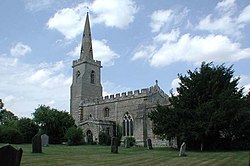
 All Saints' Church, Tilbrook | |
| Location | |
| Grid reference: | TL079680 |
| Location: | 52°18’-0"N, 0°25’12"W |
| Data | |
| Post town: | Huntingdon |
| Postcode: | PE28 |
| Dialling code: | 01480 |
| Local Government | |
| Council: | Huntingdonshire |
| Parliamentary constituency: |
Huntingdon |
Tilbrook is a small village in Bedfordshire, with a clutch of houses and single pub, and farms across the parish. It is quiet little place in undulating countryside with social life centred upon its active local community.
The village is in the Stodden Hundred of Bedfordshire and is so recorded in the Domesday Book.
Tilbrook stands on the B645 road between St Neots and Higham Ferrers, just northwest of Kimbolton. It is flat land, give over to agriculture on all sides of the village. The little River Til flows through the centre of the parish, possibly taking its name from the village and not the other way round. Tilbrook's houses are a mixture of styles; brick, half-timbered, some thatched.
The parish church, All Saints, stands on Church Lane, a beautiful church with the rectory beside it and fields each side. The church displays a rood screen, part of which is on display in the Victoria and Albert Museum.
At the centre of the village, close to the church, stands a 14th Century preaching cross, which has recently been renovated.
Tilbrook's elegant manor house dates back to the 16th Century, recently refurbished.
Name and history
The village's name comes from the Old English language, perhaps from til, meaning "good" or "capable", and broc, meaning "brook", or from a word allied to tilgian (to till).
Tilbrook appears in the Domesday Book of 1086 as Tilebroc. It was held by William de Warenne. It yielded 5 pounds, had 20 freemen and 4 smallholders, 6 ploughlands and meadow for 5 ploughs.