Difference between revisions of "Threshfield"
(Created page with "{{Infobox town |county=York |riding=West |picture=Threshfield.jpg |picture caption=Looking east to Threshfield |latitude=54.06942 |longitude=-2.01689 |population=968 |census y...") |
|||
| Line 14: | Line 14: | ||
|os grid ref=SD989637 | |os grid ref=SD989637 | ||
}} | }} | ||
| − | '''Threshfield''' is a small village and civil parish in the [[West Riding of Yorkshire|West Riding]] of [[Yorkshire]]. The civil parish originates as a township of the ancient parish of [[Linton, | + | '''Threshfield''' is a small village and civil parish in the [[West Riding of Yorkshire|West Riding]] of [[Yorkshire]]. The civil parish originates as a township of the ancient parish of [[Linton, Craven|Linton]], becoming a separate civil parish in 1866.<ref>[http://www.visionofbritain.org.uk/unit/10471977/relationships Vision of Britain website]</ref> It had a population of 980 residents in 2001, reducing to 968 at the 2011 census.<ref name="2011 census">{{NOMIS2011|id=1170216789|title=Threshfield Parish |accessdate=12 April 2018}}</ref> It borders [[Grassington]], Linton Falls and Skirethorns. Nearby villages (within seven miles radius) are [[Linton, Craven|Linton]], [[Cracoe]], [[Rylstone]], [[Hetton]], [[Hebden]], [[Kilnsey]], and [[Greenhow]]. |
== History == | == History == | ||
Latest revision as of 12:02, 24 March 2020
| Threshfield | |
| Yorkshire West Riding | |
|---|---|
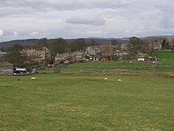
 Looking east to Threshfield | |
| Location | |
| Grid reference: | SD989637 |
| Location: | 54°4’10"N, 2°1’1"W |
| Data | |
| Population: | 968 (2011[1]) |
| Post town: | Skipton |
| Postcode: | BD23 |
| Local Government | |
| Council: | Craven |
| Parliamentary constituency: |
Skipton and Ripon |
Threshfield is a small village and civil parish in the West Riding of Yorkshire. The civil parish originates as a township of the ancient parish of Linton, becoming a separate civil parish in 1866.[2] It had a population of 980 residents in 2001, reducing to 968 at the 2011 census.[1] It borders Grassington, Linton Falls and Skirethorns. Nearby villages (within seven miles radius) are Linton, Cracoe, Rylstone, Hetton, Hebden, Kilnsey, and Greenhow.
History
Threshfield was founded by the Angles. Before 1066, the Domesday Book shows that the Viking Gamel Bern[3] was the landowner of here and Grassington, farming 840 acres of ploughland.[4] The Norman conquest made it part of the lands of Gilbert Tison. But by 1118 Tison had suffered a demotion and his lands returned to the king then given to the honours of Percy, Ramilly, Fitz John and d’Aubigny[5]
The Old Hall, a Georgian inn which takes its name from the 14th century hall at the rear, was built by monks and reputedly the oldest inhabited building in Wharfedale. In the 16th century, Threshfield was part of a huge deer park.
On pre-19th century maps, Threshfield's name is sometimes inaccurately rendered as 'Rashby'.
Sport
Threshfield is home to Wharfedale Rugby Union Football Club who play in National Division One.
On 5 July 2014, the Tour de France Stage 1 from Leeds to Harrogate passed through the village.[6]
Education
Threshfield School is a primary school for ages of 4–11 years and has approximately 108 pupils enrolled. The school was built in 1674 and is now a Grade-II listed building. Several extensions were added; In 2000, two classrooms were built as part of a stone extension.
Upper Wharfedale School is a mixed secondary school for ages 11–16 years. The school has around 320 pupils enrolled making it smaller than the average secondary school. It is a Sports College.
References
- ↑ 1.0 1.1 UK Census (2011). "Local Area Report – Threshfield Parish (1170216789)". Nomis. Office for National Statistics. https://www.nomisweb.co.uk/sources/census_2011_ks/report?compare=1170216789. Retrieved 12 April 2018
- ↑ Vision of Britain website
- ↑ Gamel Bern was the bairn of Gamel, Thegn of Mercia, and he the son of Orm or Ulf. Together this family of Noblemen held the most land in Northern England.
- ↑ Dr. Anne Williams and Prof. G H Martin, ed (1992). Domesday Book a Complete Translation. Penguin Books. ISBN 978-0-14-143994-5.
- ↑ Paul Dalton. Conquest, Anarchy and Lordship: Yorkshire, 1066-1154
- ↑ "Tour de France Stage 1". https://web.archive.org/web/20140725103624/http://www.letour.com/le-tour/2014/us/stage-1.html. Retrieved 15 July 2014.
Outside links
| ("Wikimedia Commons" has material about Threshfield) |