Difference between revisions of "Three Counties System"
(Created page with "Easter Grotto in the Ease Gill Caves In Ireby Fell Cavern The '''T...") |
|||
| Line 1: | Line 1: | ||
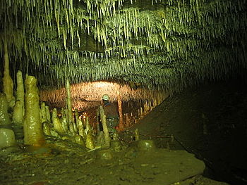
[[File:Easter Grotto Easgill.JPG|right|thumb|350px|Easter Grotto in the Ease Gill Caves]] | [[File:Easter Grotto Easgill.JPG|right|thumb|350px|Easter Grotto in the Ease Gill Caves]] | ||
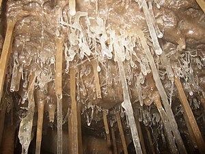
[[File:CrippleCreek Helictites1.jpg|right|thumb|300px|In Ireby Fell Cavern]] | [[File:CrippleCreek Helictites1.jpg|right|thumb|300px|In Ireby Fell Cavern]] | ||
| − | The '''Three Counties System''' is a highly complicated cave system beneath the [[Pennines|Pennine fells]] which runs beneath three counties; [[Westmorland]], [[Lancashire]] and [[Yorkshire]] (the West Riding | + | The '''Three Counties System''' is a highly complicated cave system beneath the [[Pennines|Pennine fells]] which runs beneath three counties; [[Westmorland]], [[Lancashire]] and [[Yorkshire]] (the West Riding). The system crosses the northern spur of Lancashire's main body and entrances to the caves surface in all three counties. |
For potholers, most entrances to the system require the negotiation of pitches, with some routes very tight. Rivers run in the lowest levels creating sporting streamways and flooded sections while upper levels contain large decorated passageways. | For potholers, most entrances to the system require the negotiation of pitches, with some routes very tight. Rivers run in the lowest levels creating sporting streamways and flooded sections while upper levels contain large decorated passageways. | ||
Latest revision as of 00:16, 9 December 2018
The Three Counties System is a highly complicated cave system beneath the Pennine fells which runs beneath three counties; Westmorland, Lancashire and Yorkshire (the West Riding). The system crosses the northern spur of Lancashire's main body and entrances to the caves surface in all three counties.
For potholers, most entrances to the system require the negotiation of pitches, with some routes very tight. Rivers run in the lowest levels creating sporting streamways and flooded sections while upper levels contain large decorated passageways.
The last link in the system, proving that it is indeed one connected system, was discovered only in 2011. The existence of such a major cave system beneath these fells was first proposed by David Brook in 1968, from which time many groups of cavers strove to find the connections between the known caves beneath Gragareth and Casterton fells. The effort discovered new caves and new passages, extending the known extent of the various systems beneath the fells until two vast systems had been mapped wanting a single connection for them to be one. That connection, between Lost John's Cave and Notts Pot was finally achieved on 6 November 2011 by teams led by Sam Allshorn, after they had blasted away with pressurised water the mud blockages concealing the last 460 feet of passageway.
The combined cave system is estimated to be around 630 miles long and the longest in Great Britain.
Structure of the caves
The cave is divided into several major sections, with potential in several places to connect with other nearby caves:
- The Ease Gill Caves: a system passages creating a maze-like structure, draining the nearby Easegill stream into Lancaster Hole's streamway. Lancaster Hole then forms the backbone of the section, with large passageways. It is joined by other tributaries from the other side of the backbone. The entire system is often referred to as Easegill, after this section.
- Pippikin Pot: a narrow pothole into a mature cave network, draining the far side of Ease Gill. This is then connected through Link Pot to the first major section.
- A network of flooded passages starting at Pippikin Pot, draining to the resurgence caves at Witches Cave and Leck Beck Head.
- Gavel Pot and Lost John's Cave; the latter a very extensive vertical network. Also ni this section are caves known to cavers by the telling bnames of Long Drop, Death's Head Hole and Big Meanie.
- Notts Pot and Ireby Fell Cavern.
- Large Pot and Rift Pot, which have reasonably large passages connected to Ireby Fell Cavern through tighter passages. These drain in the opposite direction to the main flow, into the currently unconnected Kingsdale Master Cave.
Statistics
Until the last connection of the Three Counties System was made in 2011, the longest connected cave in the British Isles was reckoned to be Ogof Draenen in Monmouthshire. The Three Counties System now holds that status, and its full length is not yet known: there are more passages to be explored.
The system:
- has the longest overland length of any cave in the British Isles at about 3.5 miles.
- has the longest overland distance between entrances, at 3 miles between Bull Pot of the Witches and Large Pot.
- has more entrances than any other cave system in the British Isles (around 45 at the last count)
- has caused more deaths amongst cavers, 17, than any other cave in modern days.
The break-through
The final connection of the system was made by two teams working together, on 6 November 2011. The achievement required the teams to direct high-pressure water at encrusted mud and silt, uncovering a final connecting passage.
Tim Allen, a caver in one team which made the break-through, wrote:
That last 140m has been one of the hardest to complete, burrowing through an horrendous fault zone of broken rock. This sort of digging is not for the faint hearted, commercial miners would have nightmares and we have certainly had a few close shaves. I was trapped under a collapsed boulder the size of a piano and only saved by a swift move with my crowbar. We named that spot the 'Piano Bar' after that incident. There have been a few minor injuries over the years, bashes to the face and crushed and blackened fingers, but we work as carefully as we can. Normally we have the lead diggers tunnelling at the face supported by others moving scaffolding up, and rock and mud out.[1][2]
Outside links
- UK caves: The Three Counties System
- 'Three Counties Breakthrough' - Red Rose Cave & Pothole Club, 8 November 2011
References
- ↑ 'Three Counties breakthrough' - Red Rose Cave & Pothole Club
- ↑ 'Potholers break through the final Three Counties link' – The Guardian, "The Northerner Blog", Monday 7 November 2011


