Tankersley
| Tankersley | |
| Yorkshire West Riding | |
|---|---|
 Tankersley Post Office | |
| Location | |
| Grid reference: | SK341993 |
| Location: | 53°29’24"N, 1°29’13"W |
| Data | |
| Population: | 1,671 (2011) |
| Post town: | Barnsley |
| Postcode: | S75 |
| Dialling code: | 01226 |
| Local Government | |
| Council: | Barnsley |
| Parliamentary constituency: |
Barnsley Central |
Tankersley is a village in the West Riding of Yorkshire. The 2011 census recorded a population of 1,671.
The village is to the west of junction 36 of the M1 motorway and north of the A61 road. The parish church of St Peter is to the south of the A61, as is Tankersley Manor, now a hotel. The nave and chancel of the church are 14th century. the tower 16th century, and the interior mainly 19th century.[1] It has a stained glass window designed by Edward Burne-Jones.[2] It was traditional practice for young people to join hands and form a ring around the church in a ceremony called "Embracing the Church".[1]
The parish also includes the village of Pilley to the north and the Wentworth Park Industrial Estate to the west of Tankersley village. Tankersley Post Office is part of a general store in Pilley.
The name 'Tankersley' is derived from the Old English words meaning 'Tancred's clearing'.[3]
It was the site of a battle in the Civil War 1643.[4]
Pictures

St Peter's Church
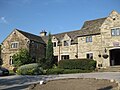
Tankersley Manor Hotel


Outside links
| ("Wikimedia Commons" has material about Tankersley) |