Swingbrow
From Wikishire
Revision as of 20:10, 19 May 2014 by RB (Talk | contribs) (Created page with '{{Infobox town |name=Swingbrow |county=Cambridgeshire |picture=Beezling pumping station - geograph.org.uk - 498312.jpg |picture caption=Beezling pumping station, Swingbrow |os gr…')
| Swingbrow | |
| Cambridgeshire | |
|---|---|
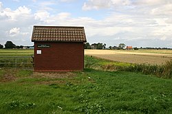
 Beezling pumping station, Swingbrow | |
| Location | |
| Grid reference: | TL3788 |
| Location: | 52°28’37"N, 0°1’30"E |
| Data | |
| Post town: | Chatteris |
| Postcode: | PE16 |
| Dialling code: | 01354 |
| Local Government | |
| Council: | Fenland |
| Parliamentary constituency: |
North East Cambridgeshire |
Swingbrow (sometimes written Swing Brow) is a hamlet near to Chatteris in Cambridgeshire. It is deep in the fenland and lies alongside the Forty Foot Drain built by Vermuyden. A Neolithic (4000 BC to 2201 BC) "perforated object" was discovered on the site, but the current buildings on the site are largely modern.
The hamlet formerly had a pub, the Ram Inn, which is now a residence, and a saddlery, now demolished. No official signs denote the hamlet because it is not safe to install these on the banks of the drain.
The hamlet comprises two roads, both ols droveways; First Drove and Second Drove.
This Cambridgeshire article is a stub: help to improve Wikishire by building it up.