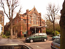
Stroud Green, Middlesex
| Stroud Green | |
| Middlesex | |
|---|---|
 Holy Trinity, Stroud Green | |
| Location | |
| Grid reference: | TQ311881 |
| Location: | 51°34’36"N, 0°6’34"W |
| Data | |
| Population: | 11,758 (2011) |
| Post town: | London |
| Postcode: | N4 |
| Dialling code: | 020 |
| Local Government | |
| Council: | Haringey |
| Parliamentary constituency: |
Hornsey and Wood Green |
Stroud Green is an urban village in eastern Middlesex, to the south of Hornsey and separated from Harringay to the east by the main railway line.
Stroud Green Road is the main local hub and shopping area. At its eastern end it intersects Seven Sisters Road and Blackstock Road at a major crossroads. Stroud Green Road is a populous thoroughfare linking Crouch Hill with the major north London transport interchange of Finsbury Park station.
Name
In 1407, the area was called Strode, which is formed from the Old English 'stod' and means 'marshy ground covered with brushwood'. It is recorded as Stowde Grene in 1546, the 'grene' suffix is Middle English and means 'village green'.[1]
About the village
The neighbourhood high street, Stroud Green Road, includes a wide range of restaurants of many different ethnic / cultural backgrounds, and other mainly independent shops. There are also two high-street supermarkets.
The Finsbury Park end of the road, though different in character to the stretch further north, is currently benefitting from a large regeneration scheme centred on Finsbury Park town centre.
Outside links
- Stroud Green Flickr Group
- Stroud Green Primary School
- Finsbury Park + Stroud Green Neighbourhood Forum
References
- ↑ Mills, D. (2000). Oxford Dictionary of London Place Names. Oxford.