Strand-on-the-Green
| Strand-on-the-Green | |
| Middlesex | |
|---|---|
 Strand-on-the-Green as seen from Kew Bridge | |
| Location | |
| Grid reference: | TQ193778 |
| Location: | 51°29’5"N, 0°16’44"W |
| Data | |
| Post town: | London |
| Postcode: | W4 |
| Dialling code: | 020 |
| Local Government | |
| Council: | Hounslow |
| Parliamentary constituency: |
Brentford and Isleworth |
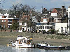
Strand-on-the-Green is a particularly picturesque Middlesex village within the conurbation filling, forming a riverside area of Chiswick. It was one of the four villages that merged to form the present-day Chiswick.
Strand-on-the-Green is immediately to the east of Kew Bridge, along the north bank of the River Thames. The name is shared by the first part of the road east of Kew Bridge, its continuation on the riverside path, and the area itself.

A footpath runs along the bank of the river, overlooked by numerous imposing 18th-century houses and local pubs, and, being a low part of the Tideway which has been narrowed with embankments on both banks, is flooded at spring tides; property flooding is rare but has occurred to basements and other storeys before the construction of the Thames Barrier.
The District line and London Overground both cross the river on the railway bridge erected in 1869 between the City Barge and Bull's Head pubs.
History
Over 100 human skulls were reportedly found in the river Thames opposite Strand-on-the-Green during the 19th century,[1] and although they have since disappeared, dating of other similar river skulls suggests they may have dated from c. 600 BC. Pottery dating from Roman times has also been found in Strand-on-the-Green.
Strand-on-the-Green is first recorded as "Stronde" in 1353 ('strand' probably means 'shore').[2] It was called 'Strand Green' in 1593 and 'Strand under Green' in 1760. Almshouses, first built in 1658, still remain, though they were replaced by new buildings in 1721–1724. It was one of the four villages (Chiswick, Little Sutton, Turnham Green and Strand-on-the-Green) that merged to form the present-day Chiswick.
The opening of Kew Bridge in 1759 (which replaced a ferry on the same spot) and the royal palace at Kew increased the importance and popularity of the area, prompting the building of large houses and the development of small industries along the waterfront. These industries included malt-houses, repair yards, barge-builders and wharves.
By 1860, Strand-on-the-Green also housed one of the largest laundries in London, the Pier House Laundry, whose brick facade is still visible to the left of Cafe Rouge. The laundry eventually closed in 1973. In the small hours of 17 January 2016, a fire badly damaged offices in the building.[3]
The area began a slow decline in the 19th century when the Grand Junction Canal diverted freight traffic to Brentford, and the Royal Family moved from Kew to Windsor. Strand-on-the-Green has now become a residential area once again, and was described in 1932 as "London's last remaining village".
During the Second World War, 41 houses in Thames Road and Magnolia Road were destroyed and a further 60 were severely damaged when a parachute mine landed on 21 September 1941.
Scenes from the Beatles' 1965 film Help! were shot in the City Barge pub and around Strand-on-the-Green.[4]
Oliver's Island

Oliver's Island is a small eyot in the river Thames opposite Strand-on-the-Green. It acquired its name after rumours that Oliver Cromwell used the island as a hideout and held military councils at the Bull's Head pub during the Civil War, but there is no hard evidence to support these rumours. The City of London's Navigation Committee erected buildings on the island after 1777, and barges were also stationed here for the collection of tolls.
Historic local pubs
Moving downstream (from west to east), the three pubs along the river at Strand-on-the-Green are:
- The Bell & Crown; licensed by 1751, closest to Kew Bridge.
- The City Barge; licensed by 1786. This pub was known as the Maypole Inn until 1807, when it was renamed after the Lord Mayor of London's barge moored nearby. The pub was largely destroyed by a bomb during the War, and the old bar is all that remains of the original inn. Featured in the 1965 Beatles film Help!
- The Bull's Head; licensed by 1722, farthest east from Kew Bridge.
The Bell & Crown
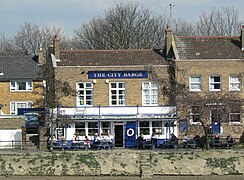
The City Barge
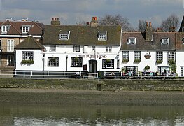
The Bull's Head


Outside links
| ("Wikimedia Commons" has material about Strand-on-the-Green) |
References
- ↑ Archaeological Journal, 1929
- ↑ Clegg, Gillian: The Chiswick Book, Historical Publications Ltd, 2004. ISBN 0-948667-96-6
- ↑ "Huge fire tears through riverside talent agency in Chiswick". Get West London. 17 January 2016. http://www.getwestlondon.co.uk/news/west-london-news/huge-fire-tears-through-riverside-10746443. Retrieved 17 January 2016.
- ↑ "Filming Locations for Help!". The Worldwide Guide To Movie Locations. http://www.movie-locations.com/movies/h/help.html. Retrieved 2008-05-26.