Stoneykirk
| Stoneykirk | |
| Wigtownshire | |
|---|---|
| Location | |
| Grid reference: | NX0853 |
| Location: | 54°49’1"N, 4°58’59"W |
| Data | |
| Population: | 1,235 (2001) |
| Post town: | Stranraer |
| Postcode: | DG9 |
| Dialling code: | 01776 |
| Local Government | |
| Council: | Dumfries and Galloway |
| Parliamentary constituency: |
Dumfries and Galloway |
Stoneykirk is a village in the heart of the Rhinns of Galloway, Wigtownshire, on the course of A716. The parish is bounded on the east by Luce Bay, and on the west by the North Channel, 5 miles south of Stranraer.
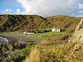
The old port for the parish, Sandhead, overlooks Luce Bay; Sandhead was formerly used for landing lime and coal.
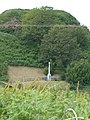
Knockinaam Lodge at Port Spittal, Stoneykirk was the venue for a secret meeting between Sir Winston Churchill and General Eisenhower during the Second World War to discuss the D-Day plans, chosen because of its remoteness.
Contents
The Village
The parish church, now disused, predates the village. The village developed around the church and is named after it.
The village has a local park with goal posts for informal football games. It has two hotels, the 3 star Torrs Warren Country House Hotel, and the original manse built in 1790 with a restaurant and bar. Cottages nearby provide self-catering accommodation.
The Village Hall is headquarters of the South Rhins Community Development Trust
Stoneykirk Church
The first church was Saint Stephen's Kirk, also found named Steeniekirk, Stephenskirk, Stevenskirk, Stainiekirk, Staneykirk and Stanykirk. The original parish was named Toskaton, recorded variously also as Toskartoun, Toscartoun, Toscarton. The kirk was dedicated to St Stephen and is thought to have been built between the 12th and 14th centuries, possibly under the patronage of the McCulloch family of Ardwell in Toskarton Parish. Toskarton and Clayshant ancient parishes were united to Stoneykirk in 1618.
In 1827 the old mediæval parish church was rebuilt.
Stoneykirk Free Church building was erected in 1844 and it passed successively to the United Free Church and the Church of Scotland, and united with Ardwell-Sandhead as Stoneykirk in 1974.
Kirkmadrine Church and old chapels
Kirkmadryne was dedicated to St Medran of Muskerry. It is no longer used as a church.
There were three chapels, St Brioch's at Kirkmabreck, St Donan's at Kildonan, and St Lashrean's at Killaser.[1]
The Monogram Stones of Kirkmadrine at Kirkmadrine Church were possibly erected about 450, and are the "earliest inscribed Christian gravestones in Scotland" and the oldest Christian monuments outside Whithorn. The oldest is a pillar stone dating from the 5th Century. All the stones were found in the immediate vicinity suggesting it was an early Christian cemetery.[2]
History
A cornerstone of McDowell's Garthland Castle (Tower House) bore the date 1211, and on another towards the east, 1274.[3]
In 1295 Sir Dougal MacDougall (McDowell) had a Charter from his 3rd cousin, King John Baliol Lord of Galloway, confirming the Barony of Garochloyne with Lougan and Elrig in the Rhinns of Galloway.
Janet McDowell (McDowall), daughter of Uchtred McDowell of Garthland, married Ninian Adair, son of William Adair of Dunskey Castle and of Kilhilt who was killed at Battle of Flodden. Uchtred McDowell, who was also killed at Battle of Flodden, appeared to own the area of Stranraer, and Ninian and Janet McDowell built the Castle of St. John, Stranraer, possibly on her father's Stranraer land. On 27 Feb 1547, in book "Inquisitiones Speciales", under "Wigton", Uthredus M'Douell was heir to his father Joannis M'Douell de Garthland who was killed at the Battle of Pinkie Cleugh, of 24 merkland of Garthland, Parish Stoneykirk, and 14 merkland of Lochans (adjoining Garthland) in Parish of Inche. On Ainslie's AD1782 map, William McDowall Esq. was shown at Garthland Castle.
On 7 July 1618 William McCulloch of Mertoun (Myretoun McCulloch Torhous in Mochrum Parish), with the consent of his eldest son Alexander, ratified a charter of Killasser in the "barony of Achowane" to William Houston and his wife Katherine Vaus.[4] Another deed of 29 June 1621, was from William Houston to William Adair, whereby James Glover, Notary Public, recorded delivery of seizin (sasine) of 4 merk land of Carnewell ( Cairnweil ), next to Kirkmadrin Church, in the Parish of Toscartoun.[5]
Killasser Castle, in ruins by the eighteenth century, was the ancient seat of the Macculloch of Ardwell.
There was a Lord Maxwell who was imprisoned by James VI and released as long as he quit Scotland. In 1588 Lord Maxwell was in Spain when the Armada was being prepared, and advised king Philip that the Galloway ports should be used. The First-class Man of War "Philip & Mary" embedded on shingle not far from Port William, Parish of Mochrum near Sir William Maxwell's Myretoun Castle on the Monreith Estate.[6]
In 1588 some vessels of the Spanish Armada, fleeing from their defeat in the Channel were wrecked off the western coast of Wigtownshire, not far from a bay which in commemoration of that circumstance, was named the Bay of Float'.[7] At Money Point or Money Head, a considerable number of Spanish dubloons were subsequently discovered.[7] Another theory for Moneyhead is that it derives from the Irish Gaelic "monadh", 'the hill-head', and that the name 'Float' is the Norse "flott", which means 'plain'; less romantic if possibly realistic.
Pictures
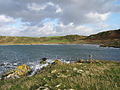
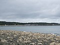
Western shore
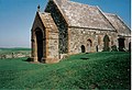
Kirkmadrine Church
Knockinaam Lodge
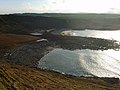
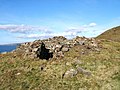
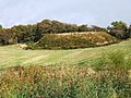
Float Bay with ancient forts
view from hill fort, Drumbreddan Bay
Ardwell Bay
Doon Castle Broch
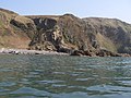
Portayew Bay and Kirklauchline fort


._-_geograph.org.uk_-_75859.jpg)


Eastern shore=
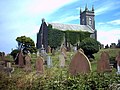
Stoneykirk Church and graveyard
Motte and Bailey castle, Ardwell
Chapel Rossan Bay looking across to Ardwell
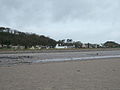
Sandhead
Balgreggan, Sandhead, Stoneykirk


Outside links
| ("Wikimedia Commons" has material about Stoneykirk) |
References
- ↑ Fasti Ecclesiae Scoticanae. New Edition. Vol.II. pp.352-355 http://www.archive.org/stream/fastiecclesiu02scotuoft#page/n363/mode/2up
- ↑ megalithic Portal
- ↑ RCAHMS
- ↑ Great Seal of Scotland pp.744-745 no.2054
- ↑ Cairnweil view from Kirkmadrin Church. http://www.geograph.org.uk/photo/3100163
- ↑ The Hereditary Sheriffs of Galloway. Sir Andrew Agnew. pub.1893. p.214
- ↑ 7.0 7.1 The Hereditary Sheriffs of Galloway. Sir Andrew Agnew