Stevenage
| Stevenage | |
| Hertfordshire | |
|---|---|
 Stevenage Town Centre | |
| Location | |
| Grid reference: | TL238241 |
| Location: | 51°54’-0"N, 0°12’0"W |
| Data | |
| Population: | 87,100 (2016 est) |
| Post town: | Stevenage |
| Postcode: | SG1 - 2 |
| Local Government | |
| Council: | Stevenage |
| Parliamentary constituency: |
Stevenage |
Stevenage is a new town in Hertfordshire. An old Hertfordshire town, it was one of the earliest of the New Towns, designated in 1946, and its character today is now not of the quiet country town of yesteryear but of an uncompromising, often brutal, modernist urban contrivance.
The town's population in 1801 was 1,430, and 4,049 in 1901, but 79,724 in 2001 and estimated at 87,100 in 2016. The largest increase occurred in the 1950s and 1960s, after Stevenage's development as a new town, absorbing London overspill.
Contents
Name of the town
The name of Stevenage may derive from Old English stiþan æce meaning 'at the stiff oak', which can also be expressed stifan æce. The name was recorded as Stithenæce, c.1060 and Stigenace in 1086 in the Domesday Book.
History
Stevenage lies near the Roman road that ran from Verulamium to Baldock. Some Romano-British remains were discovered during the building of the New Town, and a hoard of 2,000 silver Roman coins was discovered in 1986 during new house building in the Chells Manor part of Stevenage. The most substantial evidence of activity from Roman times are the Six Hills, six tumuli by the side of the old Great North Road; presumably the burial places of a local family.
The village which grew into Stevenage was founded in the early Anglo-Saxon period a little to the east of the Roman sites. Here in time the first church and manor house were built. Other villages were nearby at Chells, Broadwater and Shephall, now incorporated within the town.
In the Domesday Book, the manor of Stevenage was held by the Abbot of Westminster. The village had moved down to the Great North Road. The earliest part of St Nicholas Church dates from the 12th century, but it was probably a site of worship much earlier. The known list of priests or rectors is relatively complete from 1213.
The remains of a mediæval moated homestead are found in Whomerley Wood. All that can be seen is an 80-yard square trench, almost 5 feet wide in parts. It was probably the home of Ralph de Homle, and both Roman and later pottery has been found there.
In 1281, Stevenage was granted a Royal Charter with permission to hold a twice-weekly market and annual fair. Both were probably held in the wide part of the present High Street to the north of Middle Row. The High Street is closed for the annual fair to this day.
Around 1500 the Church was much improved, with decorative woodwork within, and with the addition of a clerestory.

In 1558, Thomas Alleyne founded a free grammar school for boys, Alleyne's Grammar School, which had an unbroken existence until 1989. Francis Cammaerts was headmaster of the school from 1952 to 1961. The school (now a mixed comprehensive school) still exists on its original site at the north end of the High Street. A plan to move the school to Great Ashby has been stopped for reasons of cost.
Stevenage's prosperity came in part from the North Road, which was made a turnpike road in the early 18th century. Many inns in the High Street served the stage coaches, 21 of which passed through Stevenage each day in 1800.
In 1857 the Great Northern Railway was driven though to Stevenage, and the era of the stage coach ended. Stevenage grew only slowly throughout the 19th century and a second church (Holy Trinity) was built at the south end of the High Street. In 1861 Dickens commented "The village street was like most other village streets: wide for its height, silent for its size, and drowsy in the dullest degree. The quietest little dwellings with the largest of window-shutters to shut up nothing as if it were the Mint or the Bank of England."

In 1928, Philip Vincent bought the HRD Motorcycle Co Ltd out of receivership, immediately moving it to Stevenage and renaming it the Vincent HRD Motorcycle Co Ltd. He produced the legendary motorcycles, including the Black Shadow and Black Lightning, in the town until 1955.
Stevenage New Town
After the Second World War, the Abercrombie Plan called for the establishment of a ring of new towns around London. Stevenage was designated the first New Town on 1 August 1946.
The plan was not popular with local people who protested at a meeting held in the town hall before Lewis Silkin, minister in the Labour Government of Clement Attlee. As Lewis Silkin arrived at the railway station for this meeting, some local people had changed the signs 'Stevenage' to 'Silkingrad'. Silkin was obstinate at the meeting, telling a crowd of 3,000 people outside the town hall (around half the town's residents): 'It's no good your jeering, it's going to be done.' His remark caused a legal challenge on the basis that the minister had not considered the matter as required to do, and a local referendum showed 52% (of a turnout of 2,500) 'entirely against' the expansion. Nevertheless, despite the hostile reaction to Silkin, the plan went ahead.[1] The New Towns Commission mollified the townsfolk by assuring them that the Old Town would not be touched, but even so the first significant building they destroyed was the Old Town Hall in which the plan had been so vocally opposed.
In keeping with the sociological outlook of the day, the town was planned with six self-contained neighbourhoods. The first two of these to be occupied were the Stoney Hall and Monks Wood "Estates" in 1951. Next to be built and occupied by the London 'overspill' was Bedwell in 1952 – The Twin Foxes pub was Stevenage's first "new" public house and is still situated in the Bedwell estate. The public house was named after local notorious identical twin poachers (Albert Ebenezer and Ebenezer Albert Fox). Next came Broadwater and Shephall (1953), then Chells in the 1960s and later Pin Green and Symonds Green. Another area to the north of the town is the twenty-first century development of Great Ashby.
Modernity has looked to the town's history in soe respects for inspiration of naming at least: the name of the pub "Edward the Confessor" (closed in 2006) could have a connection to the time in which the St Mary Church in nearby Walkern was built, for King Edward ruled from 1042 until his death in 1066. Walkern's village church dates from this time. The second pub with a strong bond to local history seems to be the "Our Mutual Friend" in Broadwater, for the name of the pub is the title of a novel by Charles Dickens, who was at some occasion guest to Sir Edward Bulwer-Lytton in nearby Knebworth House and knew Stevenage very well.
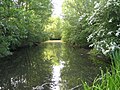
Fairlands Valley Park
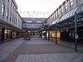
Pedestrianised Town Centre
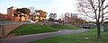
Cycle Track in Roundabout
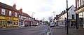
High Street in the Old Town


The pedestrianised town centre was the first purpose built traffic-free shopping zone in Britain, and was officially opened in 1959 by the Queen.[2] By the clock tower and ornamental pool is Joyride, a mother and child sculpture by Franta Belsky. Although revolutionary for its time, the town centre is showing signs of age and in 2005 plans were revealed for a major rebuilding is due to take place over the next decade, money permitting. Details are still being debated.
Next to the Town Gardens, the Church of St George and St Andrew is an example of modern church design, and has housed Stevenage Museum in its crypt since 1976. The church is a 'cathedral-like' Grade II-listed building. It is also the largest parish church to have been built in England since World War II. Her late Majesty Queen Elizabeth the Queen Mother laid the Foundation Stone in July 1956 and was also present at the consecration by the Bishop of St Albans, the Right Reverend Michael Gresford-Jones, on Advent Sunday 27 November 1960. The frame is constructed from a 'continuous pour' of concrete into moulds creating interlacing arches and leaving no apparent joints. There are twelve Purbeck marble columns about the Communion Table and the external walls are clad in panels faced with Normandy pebble. The campanile houses the loudspeakers for an electro-acoustic carillon.

In the old town centre of Stevenage, next to St Nicholas Church, in the parochial house there, called Rooksnest ("under the big wych-elm"); the novelist Edward Morgan Forster lived from 1884 to 1894. Stevenage later acquired a monument through him, when he had Rooksnest in mind as a role model for the setting of his novel Howards End. In the preface of one paperback edition of Howards End, there is a lot to be found about landmarks of Stevenage and their relationship to the story of the novel, such as the Stevenage High Street and the Six Hills. The land north of St Nicholas Church, known as Forster Country, is the last remaining farmland within the boundary of Stevenage borough.[3] Forster was unhappy with the development of new Stevenage, which would, in his words, 'fall out of the blue sky like a meteorite upon the ancient and delicate scenery of Hertfordshire'.[1]
Also close to Stevenage is Knebworth House, a gothic stately home and venue of globally well-known rock concerts since 1974. The house was once home to Sir Edward Bulwer-Lytton, Victorian English novelist and spiritualist, who, as reported by one of his visitors, was so deep in the belief of spiritual realities that he sometimes thought himself to be invisible while others were around.
Adjacent to, yet separate from the residential parts of the town, is the Industrial Area. For many years, British Aerospace (now MBDA) was the largest employer in the town, but now GlaxoSmithKline has a large pharmaceutical research laboratory complex (known as 'The Palace' to many of its inhabitants). A smaller but interesting enterprise is Astrium which has for some decades (as part of British Aerospace and its predecessors) manufactured spacecraft, both as prime contractor and equipment supplier. There are many small to medium size firms as well.
The town is still growing. It is set to expand west of the A1(M) motorway and may be further identified for development depending on the outcome of the Examination In Public of the Regional Spatial Strategy. The main area of recent development is Great Ashby to the northeast of the town.
Stevenage holds a number of annual events, including the Stevenage Day, Rock in the Park and Stevenage Carnival.
Churches

Some of the churches of the town are:
- Church of England:
- Holy Trinity
- St Andrew and St George
- St Mary’s (Graveley)
- http://www.astonstmary.org/shephall/index.htm St Mary's] (Shepall)
- St Mary The Virgin, Walkern
- St Nicholas
- St Peter's
- St Peter’s, Benington
- Church of England shared churches:
- St Hugh & St John (jointly with Methodist Church)
- All Saints (jointly with Methodist and Roman Catholic congregations)
- Church of Christ the King (jointly with United Reformed and Roman Catholic congregations)
- Great Ashby Community Church (Baptist/Anglican joint project)
- Baptist: Bunyan
- Independent evangelical:
- Methodist:
- High Street Methodist Church
- St Paul's
- New Frontiers Network: Grace Community Church
- Pentecostal:
- Stevenage Pentecostal Church (Assemblies of God)
- Elim Pentecostal Church
- Salvation Army
- Society of Friends (Quakers)
- United Reformed Church:
- United Reformed Church, Bedwell
- (also shared churches)
- Coptic:
- Coptic Othodox Cathedral of St George
- Archangel Michael & Saint Anthony
- Salvation Army
- Roman Catholic:
- The Church of The Transfiguration
- St Hilda’s
- St Joseph’s
Transport
A distinctive feature of Stevenage is its urban landscape. It has many roundabouts, few traffic lights, a network of completely segregated cycle tracks, and some of the tallest street-lights in Britain.
Stevenage is close by the A1(M) motorway, taking traffic both north and south. It is also on the smaller A602 road taking traffic southeast, meeting the A10 road at Ware.
References
- ↑ 1.0 1.1 David Kynaston (2008). Austerity Britain 1945–51. Bloomsbury. pp. 161, 162. ISBN 9780747599234.
- ↑ McKean, Charles (1982). Architectural guide to Cambridge and East Anglia since 1920. Royal Institute of British Architects. p. 174. ISBN 9780907598015.
- ↑ "Where is Forster Country?". Friends of the Forster Country. 28 August 2007. http://forstercountry.org.uk/index.php?option=com_content&task=view&id=15&Itemid=27. Retrieved 23 August 2009.