Stanwell Moor
| Stanwell Moor | |
| Middlesex | |
|---|---|
 Semi-detached and maisonette estate of Stanwell Moor | |
| Location | |
| Grid reference: | TQ0374 |
| Location: | 51°27’50"N, 1°-30’0"W |
| Data | |
| Population: | 1,371 (2011[1]) |
| Post town: | Staines-upon-Thames |
| Postcode: | TW19 |
| Dialling code: | 01753 |
| Local Government | |
| Council: | Spelthorne |
| Parliamentary constituency: |
Spelthorne |
Stanwell Moor is a village in Middlesex, close to the border with Buckinghamshire. It is immediately east of the M25 motorway and a mile south-west of Heathrow Airport Terminal 5.
The River Colne runs to the west of Stanwell Moor and the village is in Colne Valley regional park.
Stanwell Moor is distinct from Stanwell, approximately a mile to the east, although it is part of the same ward, and ecclesiastical parish.
History and geography
- Main article: Stanwell
The locality gained its main barrier from what had always been its village in the early 1960s, a dual carriageway and it hived off shortly after with the building of a community hall and establishment of its own residents' association. It is however, ecclesiastically, still strongly tied with Stanwell in the Church of England, its parish. Fewer than six of the original mediæval buildings stand in the hamlet.[2]
It sits on the part of the parish on strongly fertile, partly densely wooded, alluvial soil, whereas most of Stanwell was associated with the stony ground which makes up gravel deposits near to the surface of the soil, as throughout the area south of Heathrow Airport to the River Thames.[2]
Amenities
A parade of shops is here, followed at one end by a pub. A further pub is by the Colne itself. Distributaries of the complex River Colne runs past Stanwell Moor where it forms a broad part of the Colne Valley regional park. Stanwell Moor is buffered from all other settlements. Its south is covered by the King George VI Reservoir after which is Staines upon Thames. South-west is the Wraysbury Reservoir.[2][3][4]
Gallery
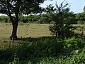
Field of Lower Mill Farm from the public footpath
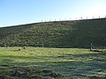
King George VI Reservoir with field used for sheep farming
.jpg)

References
| ("Wikimedia Commons" has material about Stanwell Moor) |
- ↑ Key Statistics; Quick Statistics: Population Density United Kingdom Census 2011 Office for National Statistics Stanwell Moor makes up 2011 lower output area Spelthorne 001D). Retrieved 21 November 2013
- ↑ 2.0 2.1 2.2 Susan Reynolds (Editor) (1962). "Stanwell: Introduction". A History of the County of Middlesex: Volume 3: Shepperton, Staines, Stanwell, Sunbury, Teddington, Heston and Isleworth, Twickenham, Cowley, Cranford, West Drayton, Greenford, Hanwell, Harefield and Harlington. Institute of Historical Research. http://www.british-history.ac.uk/report.aspx?compid=22238. Retrieved 15 December 2013. Add to my bookshelf
- ↑ "Google Maps". https://www.google.com/maps.
- ↑ Grid square map Ordnance Survey website