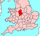
Staffordshire
| Staffordshire United Kingdom | |

| |
|---|---|
| Flag | |
| The knot unites | |

| |
| [Interactive map] | |
| Area: | 1,171 square miles |
| Population: | 2,159,392 |
| County town: | Stafford |
| Biggest town: | Wolverhampton |
| County flower: | Heather [1] |
The County of Stafford is a shire in the Midlands. The southern towns of the county form part of the Black Country conurbation and in the centre of Staffordshire is the industrial heartland of Stoke-on-Trent. Elsewhere are fine rural parts.
Geography
Cities
Towns
- Burtnwood
- Cannock
- Leek
- Newcastle-under-Lyme
- Rugeley
- Stafford
- Stone
- Uttoxeter
- Walsall
- Wednesbury
- West Bromwich
- Willenhall
Villages
Boundary towns
- Tamworth - partly in Warwickshire
This county article is a stub: help to improve Wikishire by building it up.
| Counties of the United Kingdom |
|---|
|
Aberdeen • Anglesey • Angus • Antrim • Argyll • Armagh • Ayr • Banff • Bedford • Berks • Berwick • Brecknock • Buckingham • Bute • Caernarfon • Caithness • Cambridge • Cardigan • Carmarthen • Chester • Clackmannan • Cornwall • Cromarty • Cumberland • Denbigh • Derby • Devon • Dorset • Down • Dumfries • Dunbarton • Durham • East Lothian • Essex • Fermanagh • Fife • Flint • Glamorgan • Gloucester • Hants • Hereford • Hertford • Huntingdon • Inverness • Kent • Kincardine • Kinross • Kirkcudbright • Lanark • Lancaster • Leicester • Lincoln • Londonderry • Merioneth • Middlesex • Midlothian • Monmouth • Montgomery • Moray • Nairn • Norfolk • Northampton • Northumberland • Nottingham • Orkney • Oxford • Peebles • Pembroke • Perth • Radnor • Renfrew • Ross • Roxburgh • Rutland • Selkirk • Shetland • Salop • Somerset • Stafford • Stirling • Suffolk • Surrey • Sussex • Sutherland • Tyrone • Warwick • West Lothian • Westmorland • Wigtown • Wilts • Worcester • York |