St Cyrus
| St Cyrus Gaelic: Eaglais Chiric Scots: Saunt Ceerus | |
| Kincardineshire | |
|---|---|
 St Cyrus Church | |
| Location | |
| Grid reference: | NO7171 |
| Location: | 56°46’30"N, 2°24’57"W |
| Data | |
| Population: | 1,100 |
| Post town: | Montrose |
| Postcode: | DD10 |
| Dialling code: | 01674 |
| Local Government | |
| Council: | Aberdeenshire |
| Parliamentary constituency: |
W. Aberdeenshire & Kincardine |
St Cyrus formerly Ecclesgreig (from Gaelic: Eaglais Chiric) is a village and parish in the far south of Kincardineshire adjacent to the border with Angus.
Contents
General information
St Cyrus National Nature Reserve lies between the village and the North Sea. The cliffs and dunes provide a nationally important habitat for flowering plants and insects.[1] Traditional salmon fishing with nets is still conducted from St Cyrus beach. Two ice houses that used to provide ice for packing salmon before transporting to market can still be seen. One is to the north end of the beach on the donkey track just below the Woodston Fishing Station, the other is further south next to Kirkside [this is now a private dwelling], not far from the Nature Reserve Visitors' Centre.
Area pre-history
There are known pre-historical archaeological sites in the general coastal area of St Cyrus. Examples of these features include Gourdon Hill[2] to the north and the Stone of Morphie,[3] both situated slightly to the west of the A92 road alignment.
History
The remains of the Kaim of Mathers is located on rock pinnacles on the northernmost part of the beach. Built by the Berkeley (or Barclay) family, it was used as a refuge by David de Berkely from the vengeance of the king when, around 1420, he was part of a group who murdered the local sheriff, John Melville of Glenbervie.[4][5]
St Cyrus was on the Montrose to Inverbervie branch line of the North British Railway. This line was closed as part of the Beeching cuts in the 1960s. Evidence for the line can still be seen in the viaduct over the North Esk river to the south of St Cyrus and the remains of some railway embankments and road bridges to the north.
A Home Chain Low radar station was once situated on the cliffs immediately to the south of the village. A blockhouse can still be seen at its location.
Services
St Cyrus has a convenience store located on the main road, which also serves as the Post Office. Opposite the store there is a public phone box. The village has two coffee shops along the main road. There is a public convenience on the junction of the A92 and Ecclesgreig Road at the north of the village.
St Cyrus has a public hall located not far from the store on the A92. It is used for meetings of the local community council[6] and a range of other activities. There is a sports pavilion at the local park, with an all-weather pitch and bowling green.
The Mearns Leader is the local newspaper, which is supplemented by a local community radio station, Mearns FM, that broadcasts from nearby Stonehaven.[7] The station is not-for-profit, and is volunteer run under a Community Radio Licence.[8]
A defibrillator is located on Ecclesgreig Road.
Transport
St Cyrus is on the A92 road that runs from Fife to Stonehaven where it joins the A90 and continues to Aberdeen and beyond.
St Cyrus is on National Cycle Route 1 - Shetland to Dover.
The nearest railway stations are at Montrose, five miles away, Laurencekirk, seven miles away and Stonehaven, 18 miles away.
Buses run between Montrose, St Cyrus and other coastal settlements up to Stonehaven and onward to Aberdeen.[9]
The nearest airport is at Aberdeen approximately 40 miles to the north.
Gallery
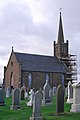
St Cyrus Church
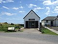
The visitor centre at the Saint Cyrus National Nature Reserve
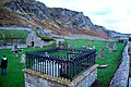
St Cyrus ancient kirkyard
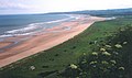
St Cyrus Beach


References
- ↑ "Scottish Natural Heritage". http://www.nnr-scotland.org.uk/reserve.asp?NNRId=29. Retrieved 2007-07-01.
- ↑ RCAHMS archaeological database: Gourdon
- ↑ C.Michael Hogan, Stone of Morphie, 2007, The Megalithic Portal, ed. A. Burnham
- ↑ Electric Scotland - Barclays
- ↑ Geograph - Kaim of Mathers
- ↑ "Aberdeenshire Community Councils". http://www.aberdeenshire.gov.uk/communitycouncils/kincardine.asp.
- ↑ "Mearns FM". http://mearnsfm.org.uk/.
- ↑ Mearns FM launch Press Release
- ↑ "Local Bus Timetables". http://www.aberdeenshire.gov.uk/publictransport/timetables/service.asp.
Outside links
| ("Wikimedia Commons" has material about St Cyrus) |